Bicycle Level of Traffic Stress (LTS) GIS Story Map

View the new GIS Story Map. It showcases DelDOT’s Bicycle LTS model that provides a basis to plan for a bicycle-friendly Delaware. Low-stress bicycle networks should produce a comfortable experience for bicyclists, of all ages and abilities, through a connected system of low-speed local roads, off-street trails, and on-street bicycle facilities. Bicycle Level of Traffic Stress (LTS) refers to the idea that a set of criteria and measures of low-stress connectivity can be used to evaluate and guide bicycle network planning. The Delaware Department of Transportation (DelDOT) has developed a Bicycle LTS model, available on First Map, the State of Delaware’s GIS portal, to help visualize and plan for a bicycle-friendly Delaware. This GIS Story Map showcases the Bicycle LTS Model, highlights ways to assess bicycle LTS in a community, and can be used as a basis to plan for a bicycle-friendly Delaware.

Visit the Complete Communities YouTube Channel


Banner image depicting small screenshot examples of Complete Communities YouTube videos. The banner directs people to visit the Complete Communities YouTube Channel

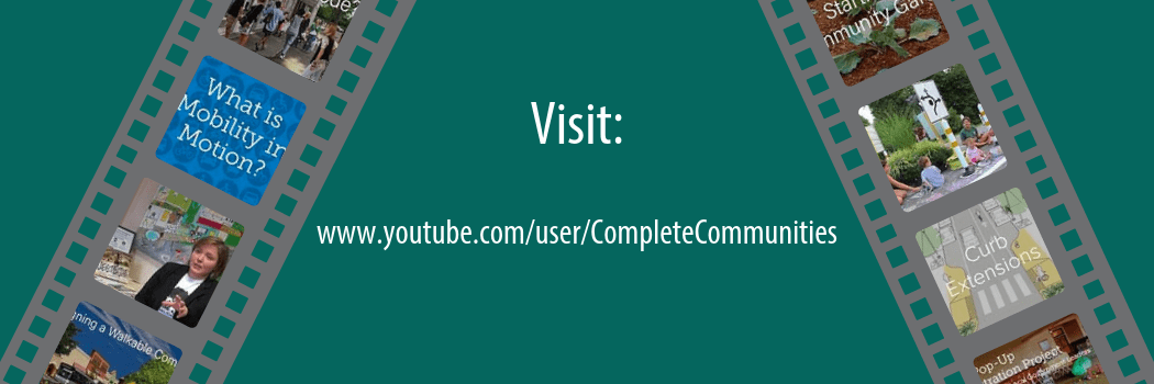
Explore the Complete Communities YouTube Channel for visually engaging tools to help you plan for communities that are attractive, inclusive, efficient, healthy, and resilient places. Check out our playlists for video series that feature interesting topics. Get to know creative placemakers in Delaware with the Stories of Delaware’s Complete Communities playlist that highlights innovative placemaking projects across Delaware. Watch the Delaware Byways playlist to take a journey through the scenic byways of Delaware’s natural landscape. New videos are posted frequently. From interviews with local experts to showcasing new policy strategies, the YouTube channel has something to offer for everyone interested in planning for complete communities.

Upcoming Events in IPA’s Planning Education Training Program

Delaware’s municipalities are increasingly being asked to focus much of their attention on the state’s expected new growth and development. Municipalities must make difficult decisions that can have long-lasting impacts on the community’s character, economy, and quality.

The Delaware Planning Education Program is a voluntary certificate program comprising an organized series of educational courses designed to meet the responsibilities of municipalities as partners in planning Delaware’s future. The program is offered in partnership with the Office of State Planning Coordination and the Delaware Chapter of the American Planning Association.

Advanced Land-Use and Development Administration

“Planning 203” is a new hands-on course designed to provide participants with table-top exercises to build their skills for administering and interpreting land-use regulations.

March 24, 2017 | 9 a.m. to noon | University of Delaware Paradee Center | Dover, Del.
Cost: $50 | Instructors: Linda Raab, AICP, and Ann Marie Townshend, AICP

Register now | download workshop flyerPDF icon | Registration deadline: March 23

Developing Your Strategy for Economic Development

Whether a formal report adopted by council or a back-of-the-envelope exercise worked out on-the-fly, an economic development strategy can work to guide municipal decision-making and encourage private investment in your community. “Planning 213” is a new session that advances concepts and principles for scoping, developing, and implementing your community’s economic development strategy.

April 28, 2017 | 9 a.m. to noon | University of Delaware Paradee Center | Dover, Del.
Cost: $50 | Instructors: Troy Mix, AICP; Maureen Feeney Roser; and Ann Marie Townshend, AICP

Register now | download workshop flyerPDF icon | Registration deadline: April 27

Creating a Flood Ready Community

This popular course returns for the fourth year. “Planning 201” reviews the multiple sources of flood risks to Delaware communities that can be addressed and mitigated through planning, codes, and ordinances. It covers floodplain requirements for municipalities and tools for adapting to flood risk. Sources of funding and technical assistance will also be presented. Catered lunch and networking session will immediately follow the training, from noon–1 p.m.

May 19, 2017 | 9 a.m. to noon | University of Delaware Paradee Center | Dover, Del.
Cost: $50 | Instructors: Phil Barnes, PhD; Danielle Swallow; and Greg Williams

Register now | download workshop flyerPDF icon | Registration deadline: May 18

A limited number of registration fee waivers are available for municipal officials, based on financial need. Fees will be covered by the Delaware Coastal Training Program. To request a fee waiver, please email Kelly Valencik, Coastal Training Program Coordinator at kelly.valencik@state.de.us.

Creating ADA-Accessible Communities

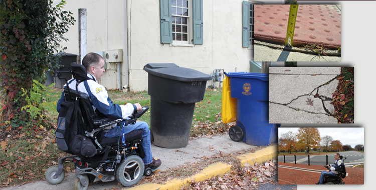
This video, entitled Creating ADA-Accessible Communities, highlights Americans with Disabilities Act (ADA) accessibility issues within pedestrian environments. The video features DelDOT ADA Title II Coordinator John McNeal using a Go-Pro camera to record, from his perspective, common ADA challenges navigating pedestrian facilities in an urban setting.

Under ADA Title II, public entities (including state and local governments) are required to ensure accessible design, construction, and maintenance of all transportation projects—including pedestrian facilities. Pedestrian facilities include public sidewalks, shared-use paths, curb ramps, crosswalks, pedestrian islands, pedestrian signals, transit stops, and other pedestrian features within the public right-of-way. However, persons with disabilities often face accessibility barriers caused by physical obstructions, improper design, or insufficient maintenance of pedestrian infrastructure.

Jurisdictions must address these issues to ensure that access for persons with disabilities is provided wherever a pedestrian facility is newly built or altered. To comply with ADA, the same degree of convenience, connection, and safety afforded the public must also be available to pedestrians with disabilities. Ultimately, pedestrian facilities must be readily accessible to and usable by persons with disabilities.

For more information on ADA Title II requirements, the role of local governments, and steps to achieve compliance, please visit the ADA section of the toolbox.

How bikeable is your community?

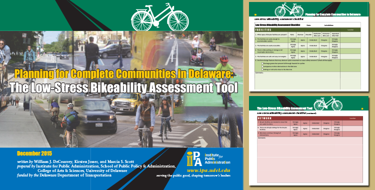
Use the newly developed Low-Stress Bicycling Assessment Tool to find out!

Planning for Complete Communities in Delaware: The Low-Stress Bikeability Assessment Tool  is a resource for Delaware local governments that are considering ways to improve the low-stress bikeability for areas within their community. It is designed to guide local governments in evaluating the extent to which average bicycle riders can easily access low-stress areas, and in developing strategies to leverage state investments to improve local cycling networks and bicycle infrastructure. The Low-Stress Bicycling Assessment Tool should be used in combination with DelDOT’s maps to help communities target high-priority locations to plan for infrastructure improvements, bridge network connectivity gaps, and enhance low-stress conditions for the average bicyclist.

Learn more about low-stress cycling and how to use the assessment in this new section of the Toolbox.


How Walkable is Your Community?

Cover of the new 2016 Healthy and Complete Communities in Delaware: The Walkability Assessment Tool Walkable, pedestrian infrastructure is a key element of a “Complete Community.” When sidewalks, parks, and trails are pleasant places to walk, all community members benefit. Unfortunately, not all places are walkable, but with the help of IPA’s Walkability Assessment Tool, citizens achieve positive changes.

Visit the Walkable Communities section of the toolbox to learn more about ways to improve pedestrian infrastructure. This section includes:

New Guide to Transportation Improvement Districts

tid-guide-coverTo help Delaware local governments better understand DelDOT regulations that govern the process to plan for and establish a TID, the Institute for Public Administration developed an electronic publication, Transportation Improvement Districts: A Guide for Delaware Local Governments.

Funded by the Delaware Department of Transportation (DelDOT), the guide discusses the purpose, benefits, and TID planning framework in Delaware.

It also provides a step-by-step process for Delaware local governments to follow to create TID(s) and two best-practice examples for planning (City of Newark) and implementation (City of Dover) of TIDs in Delaware.

The downloadable guide is part of a comprehensive set of online tools on TIDs within the Complete Streets element of Delaware Complete Communities Planning Toolbox, available here.


What is a Complete Street?

Dan Burden, a champion for walkability and Complete Streets has issued a post on AARP’s blog regarding Complete Streets as a necessity for all generations.  Burden states, “If we invest in complete streets now, then not only will we all be happier and healthier as we age, but one day our children will thank us — especially if they don’t have to drive across town, or even a few blocks, to help us across the street.”