
Flood Vulnerability of Delaware Communities
Delaware is extremely susceptible to the dangers of flooding. It is one of only three states in which 100 percent of its population lives in coastline counties, according to a census report. An article published by Delaware’s Department of Natural Resources and Environmental Control (DNREC), Sea Level Rise: Delaware’s Rising Tide, describes possible impacts of sea level rise in the First State. It explains that Delaware is vulnerable to coastal inundation, storm surge, saltwater intrusion, tidal wetland losses, nuisance flooding from high tides, and inland flooding from extreme participation—all of which will be exacerbated by the looming threats of higher rates of sea level rise. Also, each year, 10 – 35 storms such as nor’easters and tropical storms occur in Delaware, often causing flooding. All Delaware communities must evaluate risks, prepare, and implement plans to address flooding caused by storms and extreme precipitation, seasonal high “king” tides, and climate change—including sea level rise.
Because Delaware is the lowest state in the nation regarding average sea level, many think that only coastal communities or towns along bodies of water (rivers, ponds, lakes, inland bays, streams, and creeks) are impacted by flooding. This is not the case. In addition to climate change, flooding can be caused by issues associated with poor or insufficient management of stormwater, floodplains, and/or drainage—including an increase in impervious surfaces due to sprawling land use patterns and development. Flooding also impacts properties near ditches. In Delaware, there are 228 individual tax ditch organizations that manage 2,000 miles of channels that provide benefits/protection to over 10,000 Delawareans. Therefore, flood vulnerability impacts each jurisdiction in Delaware and heightens the need to make communities flood-ready and resilient.
GIS StoryMap on Freeboard
This GIS StoryMap showcases “freeboard” as a tool to achieve a Sustainable and Resilient community. When adopted as part of a floodplain management strategy, freeboard can create Flood-Ready Communities that are prepared to protect and preserve properties and lives.
Topics in this Section
- State Policy Framework
- Delaware Local Government Planning Framework: Flood-Ready Communities
- Evaluate
- Plan
- Execute
- Technical Assistance
- Funding
State Policy Framework
Delaware has a long-standing history of fostering stewardship of Delaware’s natural resources promoting wise land use, and ensuring water quality and water management practices. State policies, regulations, and programs have been developed to promote stormwater management, low-impact development, land conservation, riparian buffers, floodplain management, and land use planning strategies to mitigate flooding and adapt to flood risks. In recent years, there has been great momentum to build upon Delaware’s efforts in resiliency and adaptation.
Senate Bill 64 authorized DNREC to adopt guidance and minimum standards to reduce risk from flooding. As a result, DNREC adopted 15 floodplain standards and 6 drainage standards, along with a variety of recommendations that local governments may wish to incorporate into local codes.
Additionally, Executive Order 41, Preparing Delaware for Emerging Climate Impacts and Seizing Economic Opportunities from Reducing Emissions, set forth an action plan to address climate change, a major cause of flooding in the First State. First, it created the Committee on Climate and Resiliency. This committee was tasked with developing actionable recommendations for state agencies and local governments to improve Delaware’s preparedness and resiliency to climate change and sea level rise.
The Climate Framework for Delaware, unveiled in December 2014, summarizes the work and recommendations of three Committee workgroups that focused on Mitigation, Adaptation, and Flood Avoidance. It includes recommendations that outline Delaware’s future direction for climate action. In addition to recommended actions for state agencies, the Framework outlines the need for interagency coordination and strategies “local governments can take to improve community resiliency, and outreach strategies to inform and prepare Delaware’s residents and businesses about identified risks, vulnerabilities, adaptation strategies, and basics of climate change and its causes, with particular attention to providing strategies to help protect at-risk populations.”
Delaware Local Government Planning Framework: Flood-Ready Communities
With a variety of existing useful resources, this toolbox content provides a planning framework to equip Delaware communities with the tools necessary to transform communities into flood-ready, resilient places. Resilient communities leverage the strengths and capacities of individuals, families, businesses, schools, and hospitals to “bounce back” after flood events, rather than merely react to impacts. Community engagement is an integral process that should be prioritized throughout all stages in creating a flood-ready community. The following sections provide a process and tools for Delaware communities to evaluate risks, plan to adapt, and execute actions to address the impacts of flooding.
Evaluate
To prepare for flooding associated with storms and extreme precipitation, seasonal high “king” tides, and climate change—including sea level rise, Delaware communities must first evaluate their vulnerabilities and risks. Evaluating risk, based on past flood events, is a good starting point. However, it is important that such an assessment also incorporates knowledge-based flood projections to properly plan and address vulnerabilities of the potential for future flood events.
Conduct a Vulnerability and Risk Assessment
Vulnerability and risk assessments allow communities to evaluate their community’s vulnerability to current and future flooding problems. Delaware Sea Grant’s Natural Hazard and Climate Change Adaptation Tool Kit for Delaware Communities was developed to assist communities in identifying planning, mitigation, and adaptati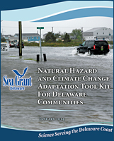 on opportunities that will help reduce vulnerabilities to natural hazards and climate impacts.
Divided into three parts, the Tool Kit provides guidance on choosing a planning approach and level of community engagement, ways to identify and prioritize vulnerabilities, and selecting actions for a hazard mitigation and climate change adaptation plan. The Tool Kit highlights the use of resources to explain the science behind climate change and geographic information system (GIS) mapping as a valuable tool to visualize flooding and inundation hazards. Using GIS maps during a public workshop enables participants to identify infrastructure, populations, economic areas, and natural resources vulnerable to flooding and inundation. Additional public input can identify vulnerabilities that are unable to be mapped and help prioritize community vulnerabilities. Once social, infrastructural, and natural vulnerabilities are identified and categorized, they should be prioritized based on their sensitivity and adaptive capacity. Next, actions should be considered, selected, and prioritized to implement a Natural Hazard Mitigation and Climate Change Adaptation Plan.
Review Maps and Data to Evaluate Risk
There are a variety of maps communities can utilize to evaluate their vulnerabilities and risks related to flooding.
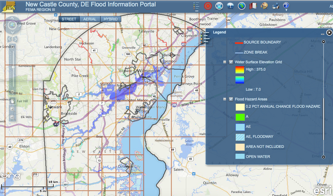
New Castle County FIRM
FEMA’s National Flood Insurance Rate Maps (FIRM) for New Castle County, Kent County, and Sussex County display flood zones and floodplain boundaries throughout Delaware for insurance purposes. This allows viewers to identify special flood hazard areas, the location of properties in relation to these areas, the base flood elevation at a specific site, the magnitude of flood hazard in an area, and many other features. These maps are based on hydrologic modeling in combination with data from previous flooding incidents. While these are regulatory maps, and their use is mandatory for many purposes, they should not be solely relied upon for flood-readiness and resiliency planning.
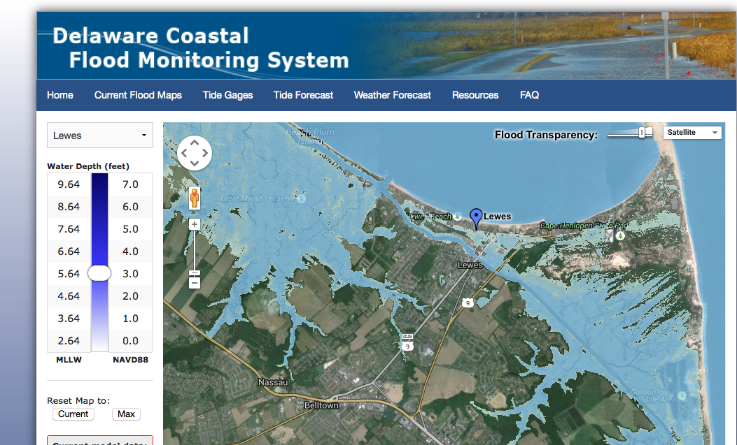
Delaware Coastal Flood Monitoring System Map
The Delaware Coastal Flood Monitoring System is a resource to assess imminent weather and current conditions. This tool, while not applicable for planning, is useful for emergency management and mitigation efforts for upcoming coastal flood events. Similarly, the Delaware Environmental Observing System provides real-time environmental conditions as well as daily and monthly summaries that can be used for emergency planning purposes.
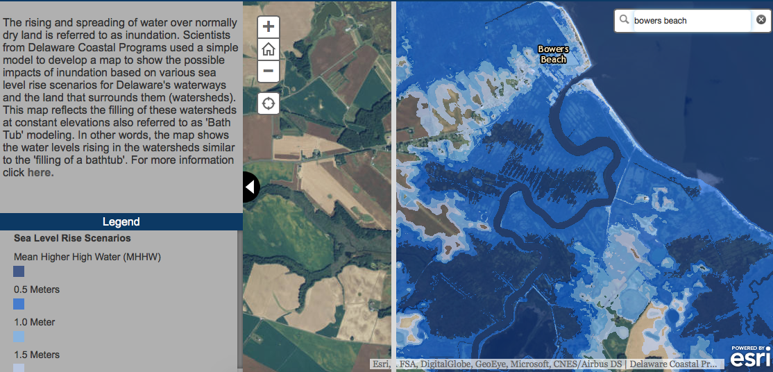
Delaware Coastal Programs Inundation Map
In addition, several maps are available to help Delaware communities evaluate the risk of future projections of flooding in their communities. Delaware Coastal Programs scientists developed Sea Level Rise Inundation Maps that illustrate how various sea level rise scenarios may impact flooding in coastal areas. Communities may use these maps to:
- Assess and plan land use and zoning ordinances to protect community resources and guide new development
- Plan for local impacts to the economy
- Develop future plans for infrastructure
- Plan for coastal community resiliency by determining risks and vulnerabilities
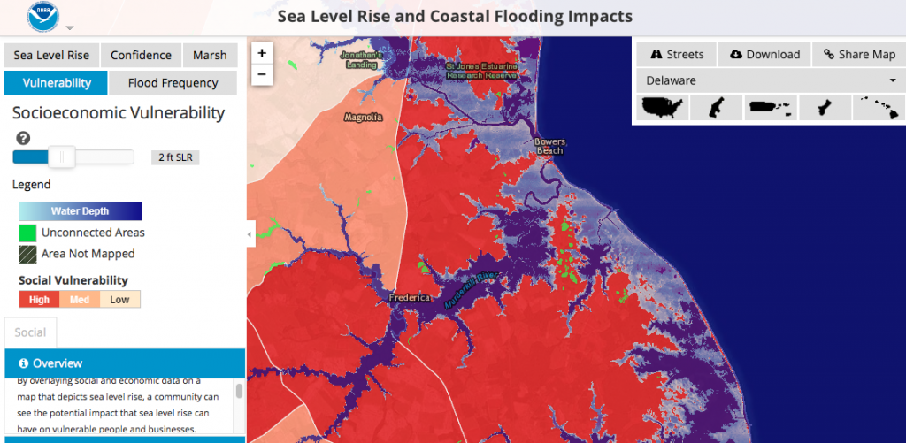
NOAA Sea Level Rise and Coastal Flooding Impacts Map
The National Oceanic and Atmospheric Administration’s (NOAA) interactive Sea Level Rise and Coastal Flooding Impacts Map provides visualizations of various sea level rise scenarios. The NOAA map also features layers of social and economic Census data that can be overlaid with sea level rise layers. This allows coastal communities to visualize the potential impacts of sea level rise and coastal flooding in vulnerable areas and properties.

Delaware Sea Grant Community Flood Visualization Map
Delaware Sea Grant, the U. S. Geological Survey, and Delaware Department of Natural Resources and Environmental Control (DNREC) have produced Community Flood Map Visualizations. Maps are provided for the following communities in Sussex County, Delaware: Fenwick Island, South Bethany, Bethany Beach, Dewey Beach, Pot Nets, Long Neck, Oak Orchard, Lewes, Milford, and Broadkill Beach. This mapping tool features an interactive before/after slider feature that allows users to visualize the extent and depth of flooding for a variety of sea level rise scenarios.
Gauge Local Government Capacity to Manage Risk
Many local governments in Delaware do not have the capacity or resources (e.g., staff, expertise, finances, and time) to adequately manage flood risk, which may impact a community’s preparedness and resiliency. Local, state, and federal governments; private and non-profit sectors; and community stakeholders must work collaboratively to plan for future flood events. Adaptive planning is an ongoing process involving coordination and partnerships. Local governments should seek assistance from experts within state agencies in developing strategies to protect critical structures such as wastewater treatment facilities from flooding, protect water supplies from flooding and saltwater intrusion, evaluate the adequacy of drainage infrastructure, and incorporate adaptive measures within planning processes.
Delaware local governments should develop operational plans and strategies, with technical assistance from state agencies and input from key stakeholders, to address potential impacts of flooding. While it is advised that each jurisdiction assign a certified floodplain manager to this role, smaller entities may not have this ability. Therefore, it is essential to designate a specific staff member to work with state agencies, local officials, and citizens to evaluate and manage flood readiness. Local governments should determine needs for technical assistance, funding, or training for staff, elected officials, planning commission members, and/or other citizen volunteers to address flood readiness associated with storms, seasonal high “king” tides, and sea level rise.

IPA Flood-Ready Workshop
Training for local government officials is offered through IPA’s Delaware Planning Education Program. Conducted in collaboration with DNREC and the Sea Grant College Program, IPA’s Planning 201—Creating a Flood-Ready Community—trains local leaders in evaluating flood risks, implementing adaptation measures through community planning, and revising codes and ordinances. State agencies also host workshops for local government officials and staff, such as DNREC’s Coastal Training Program. Lastly, the University of Delaware’s Sustainable Coastal Communities Initiative and Delaware Sea Grant provide training workshops to local government officials and decision makers.
Evaluate Education and Outreach Needs
While maps can help community members visualize the potential impacts of flooding, Delaware local governments need to engage stakeholders in the process of evaluating flood risks and planning for resiliency. Transparent and effective community engagement fosters community awareness and educates citizens about floods and strategies that need to be undertaken to protect lives, property, and community infrastructure and assets. If a local government hires an outside consultant to assess risk and plan adaptation strategies, meaningful opportunities for public involvement need to be provided.
Jurisdictions should develop a comprehensive outreach strategy to increase stakeholder involvement and understanding of current and future flood risks. Early and continuous community engagement ensures that decisions reflect public needs and interests, consider diverse viewpoints and values, and are made in collaboration and consensus with all stakeholders. This process builds mutual understanding and trust between government entities and the people they serve. Successful public participation is a deliberate and continuous process. It consists of a series of activities and actions to inform, educate, and gain input from stakeholders on decisions that affect their lives.
Public outreach initiatives can be scaled to the size and capacity of each town. Ideally, a public engagement plan should be developed to establish goals and objectives for public involvement and identify the specific approaches and tools that will be used. If it is beyond the capacity of a small town to develop a formal plan, a combination of “high-touch” (personal interaction through meetings and workshops) and “high-tech” (use of social media, digital tools, and websites) tools can be used to engage citizens in vulnerability assessment or adaption plan efforts. Early public workshops can give community members an overview of all hazards mitigation and climate change adaptation planning processes. Stakeholders should be encouraged to provide insights into current vulnerabilities in their communities and to consider how future flooding scenarios could aggravate such risks. Vulnerable infrastructure and populations (e.g., older adults, persons with disabilities, no-car households) should be given special attention.
Public information campaigns can promote awareness of flood risks and actions that need to be undertaken by the community. Local government websites can provide links to educational resources, information on the benefits and risks of adaptation measures, awareness of combined risk factors, and changes occurring in the insurance industry that may impact coverage and cost. Website links can be provided to the Delaware Complete Communities Planning Toolbox, Delaware Coastal Programs adaptation materials, DNREC’s Climate Impact Assessment resources, Delaware Sea Grant publications, and National Flood Insurance Program resources.
Local governments can enhance awareness to interested property owners about potential flood risks and insurance requirements. Jurisdictions can require prospective property owners to view zoning and floodplain maps, prior to completing a real estate sales transaction, to understand the location and possible flood threats relative to the location of the property. For example, the City of Newark’s Zoning Code requires that all prospective property owners to meet with the Planning and Development Department staff, view maps, and sign a “Deed Transfer Affidavit.” This affidavit certifies that the purchaser was informed about zoning of the property being acquired, zoning of adjacent land, and, if applicable, the location of the 100-year floodplain in relationship to the property.
Review State of Delaware Sea Level Rise Vulnerability Assessment
While other factors such as storms and high tides can cause flooding, assessing risks and planning for the long-term effects of climate change, including sea level rise, can better prepare Delaware’s communities, specifically those on the coast, in the near-term for flood events. Preparing for Tomorrow’s High Tide: Sea Level Rise Vulnerability Assessment for the State of Delaware was developed by DNREC’s Delaware Coastal Programs with input, advice and guidance from members of  Delaware’s Sea Level Rise Advisory Committee.
The document contains background information about sea level rise, methods used to determine vulnerability, and a comprehensive accounting of the extent and impacts that sea level rise will have on the state. Communities in low-lying, flood-prone, or coastal areas may use this publication as the basis for assessing their vulnerability. This includes flooding of local assets such as ecological resources and protected lands, infrastructure, future development areas, industrial lands, roads and bridges, wells and groundwater resources, and tourism and recreation areas.
Assess Adequacy of Local Plans, Policies, Codes, and Regulations
Prior to developing plans to prepare for and manage the risk of floods, jurisdictions should assess the adequacy of adequacy of existing plans as well as the jurisdiction’s regulatory framework to support flood resiliency.
First, communities should review their comprehensive plan and official maps to ensure that their environmental protection plan (e.g., content related to environmental quality and natural resources) meets Delaware Comprehensive Plan checklist requirements. Comprehensive plan should be assessed to ensure that comprehensive strategies address stormwater and watershed management, wetlands protection, floodplain protection, water resource protection areas, climate change and sea level rise.
Next, communities should review their regulatory framework to ensure it is consistent with recommendations of the comprehensive plan and other specialized plans/strategies. Community floodplain regulations should be evaluated to determine if ordinances, regulatory standards, and enforcement processes provide adequate long-term flood risk reduction and minimize overall impacts of floods. To accomplish this, the jurisdiction’s floodplain and drainage standards should be compared to the minimum standards recommended by the Floodplain and Drainage Advisory Committee, resulting from Senate Bill 64. Ideally, communities should also consider options for higher regulatory standards that exceed minimum National Flood Insurance Program’s (NFIP) regulations.
Communities should also assess and determine the adequacy of their current plans and regulations relative to recommended adaptation strategies and measures, as described within Delaware Coastal Program’s Preparing for Tomorrow’s High Tide: Recommendations for Adapting to Sea Level Rise in Delaware (Chapter 2). Four adaptation strategies may be considered:
- Protect – Building structures (e.g., walls, bulkheads, dikes, living shorelines, beach replenishment) to keep water away.
- Accommodate – Reducing flood damage by elevating homes, evacuating during storm events, and heeding high tides
- Avoid – Identifying at-risk areas and directing new development to less vulnerable areas through voluntary and regulatory measures
- Retreat – Removing structures permanently from vulnerable and flood-prone areas
The Adaptation Tool Kit: Sea Level Rise and Coastal Land Use, published by the Georgetown Climate Center, describes a range of planning, regulatory, spending, and tax and market-based tools that provide a basis for local government decision making on adaptation strategies and measures.
Delaware Flood-Ready Communities: Plan and Policy Checklist
 Lastly, IPA has developed a downloadable and printable Delaware Flood-Ready Communities: Plan and Policy Checklist. The checklist is designed to help communities evaluate the extent to which their jurisdiction has developed planning, regulatory, spending, ecosystem, economic, and community engagement tools aimed at enhancing a community’s flood readiness. Completing this checklist can help a community assess how well it is positioned to avoid, reduce, or recover from floods through a strong planning and regulatory framework.
Plan
After assessing vulnerabilities and risks, Delaware communities can develop plans to proactively address flooding. Planning strategies should build upon a local government’s comprehensive plan, which is the foundation for land use planning and serves the blueprint for growth and development. To plan for a flood-ready community, local officials should:
- Engage Stakeholders
- Adopt and Incorporate Recommendations of an All Hazards Mitigation Plan into the Comprehensive Plan
- Incorporate Flood Resiliency, Sea Level Rise, and Climate Change Adaptation into Official Local Government Plans. This includes:
- Revising, Updating, or Amending the Comprehensive Plan; or
- Preparing a Separate or “Stand-Alone” Plan (e.g., a Natural Hazards/Climate Change Adaptation Action Plan) that is adopted as an amendment to the comprehensive plan
Engage Stakeholders
Forming a Committee
While engaging the public is integral in planning for flood readiness, establishing a group of key stakeholders is essential for sustaining a community’s commitment to climate change resiliency. Local governments may form an ad-hoc committee that is specifically appointed to develop an adaptation plan. However, a jurisdiction may wish to delegate planning to an existing committee or appoint a standing committee to both prepare and implement a long-term adaption plan. The committee should be appointed by jurisdiction’s governing body (e.g., city council) and represent diverse interests. Local government committees typically comprise elected officials and staff, property owners, citizens, state agency officials, and key community stakeholders. The committee serves in an advisory role to elected officials and makes recommendations on adaptation plans, policies, and actions. Delaware Sea Grant’s Natural Hazard and Climate Change Adaptation Tool Kit for Delaware Communities suggests that a committee may:
- Help identify vulnerabilities, adaptation strategies, and implementation strategies
- Provide feedback on drafts of plans
- Draft sections of the plan
- Contribute knowledge on how sea level rise might impact government services or the population
- Form subcommittees to focus on subjects such as public health or transportation infrastructure
An external technical advisory group may also be formed as a separate committee or as part of a local government-appointed committee. This type of group could provide technical assistance, experience from having worked on similar projects, scientific knowledge, state agency expertise, and insights into funding and other implementation resources.
Delaware Examples
The Town of South Bethany formed a Sea Level Rise & Storm Surge Committee in 2013 to conduct a vulnerability assessment to identify at-risk properties and infrastructure, as well as to evaluate and recommend potential adaptation strategies. This group made community presentations about the risks and vulnerabilities of sea level rise and applied for grant funding for adaptation projects.

Lewes Mitigation Planning Team May 2015 Agenda
In 2002, the Mayor and the Council of the City of Lewes appointed members to the Lewes Mitigation Planning Team. The team was tasked with establishing an ongoing hazard mitigation program. Since then, the group has conducted a comprehensive analysis of the City’s infrastructure vulnerabilities, developed a flood mitigation plan, educated citizens about sea level rise and associated hazards, and established partnerships with other governmental entities and stakeholders.
Adopt an All Hazards Mitigation Plan and Incorporate its Recommendations into the Comprehensive Plan
According to the website of the Federal Emergency Management Agency (FEMA), “Mitigation is the effort to reduce loss of life and property by lessening the impact of disasters. This is achieved through risk analysis, which results in information that provides a foundation for mitigation activities that reduce risk, and flood insurance that protects financial investment.” According to the Code of Federal Regulations (44 CFR §201.2), “Hazard mitigation means any sustained action taken to reduce or eliminate the long-term risk to human life and property from hazards.”
Under 44 CFR §201.6, Emergency Management and Assistance, local governments are required to 1) prepare and adopt a jurisdiction-wide hazard mitigation plan as a condition of receiving project grant funds under the Hazard Mitigation Grant Program (HMGP), and 2) review and update the hazard mitigation plan every five years from date of plan approval of the previous plan in order to continue program eligibility. The development of a hazard mitigation plan demonstrates a jurisdiction’s commitment to reduce the vulnerability to future natural hazards such as hurricanes, fires, tornados, earthquakes, droughts, winter storms, and flooding.
In 2013, FEMA published an online Local Mitigation Planning Handbook to provide guidance to local governments on developing or updating hazard mitigation plans to meet the requirements of 44 CFR §201.6. It offers practical approaches and examples for how communities can engage in effective planning to reduce long-term risk from natural hazards and disasters. The handbook describes a multi-step planning process to determine the planning area, create an inclusive planning process, conduct a risk assessment, develop and keep a mitigation strategy current.

In Delaware, emergency managers with the Delaware Emergency Management Agency (DEMA) and at the county government level take the lead in developing local All Hazard Mitigation Plans for municipalities. Under the Disaster Mitigation Act of 2000 (DMA), local All Hazard Mitigation Plans must be formally adopted by the local governing body of the jurisdiction in order to be approved by FEMA.
Incorporate Flood Resiliency, Sea Level Rise, and Climate Change Adaptation into Official Local Government Plans
Revise, Update, or Adopt Amendment to Comprehensive Plan
In Delaware, local governments have the responsibility for land use planning. The comprehensive plan is the foundation for planning in Delaware. Comprehensive plans guide growth, development, and desired land use patterns and are a requirement for all local governments in Delaware. Title 22, Chapter 7, Section 702 of the Delaware Code prescribes the contents of comprehensive plans and the frequency with which they are to be reviewed or revised. The Delaware Code requires that at least every 5 years a municipality (with a population over 2,000) review its adopted comprehensive plan to determine if its provisions are still relevant. The adopted comprehensive plan must also be revised, updated, amended as necessary, and readopted at least every 10 years.
Planning for flooding is inextricably linked to future plans for land use, growth and development, and infrastructure provision—all key facets of the comprehensive plan. The Delaware Office of State Planning Coordination’s (OSPC) Municipal Comprehensive Plan Guide directs municipalities to address environmental protection within a section of the comprehensive plan. Strategies for stormwater and watershed management, wetlands protection, floodplain protection, water resource protection areas, climate change and sea level rise may be covered within the environmental protection section and other comprehensive plan elements. Strategies should also be incorporated into official maps that are prepared and adopted as part of a comprehensive plan. Provisions should be drafted and vetted in a public participation process as part of a comprehensive plan revision, update, or amendment during the required 5-year review or 10-year update. Land use regulations, such as zoning and subdivision ordinances—whether separate documents or a single land-use code—are the principal means for carrying out recommendations of a comprehensive plan.
Create and Adopt a Stand-Alone Plan(s) as a Comprehensive Plan Amendment
Most incorporated jurisdictions in Delaware have adopted All Hazard Mitigation Plans. These federally mandated plans focus on how a community should prepare for and react to disasters. However, this form of planning provides a short-term response to a disaster event and focuses on recovery. Hazard mitigation plans are based on historical information and oriented toward emergency management and public safety. They do not provide measures or direct actions that reduce the negative impacts of hazards or provide new opportunities to prepare for future impacts of flooding associated with storms, seasonal high “king” tides, and sea level rise. To address the need for proactive planning, local governments may also wish to prepare and implement stand-alone plan(s) and adopt them as an amendment to a comprehensive plan. Examples of relevant stand-alone plans include a comprehensive watershed management plan, an open space protection plan, natural land management plan, stormwater drainage study, vulnerability assessment study, a flood study conducted in accordance with FEMA criteria, and/or a Natural Hazards/Climate Change Adaptation Action Plan.
As described in Delaware Sea Grant’s Natural Hazard and Climate Change Adaptation Tool Kit, the development of a long-term Natural Hazards/Climate Change Adaptation Action Plan ideally builds upon a jurisdiction’s existing hazard mitigation plan, other plans (e.g., open space protection, watershed management, comprehensive plans), policies (e.g., floodplain management ordinances, building and zoning codes), and programs (e.g., land acquisition or land management). These plans enable a community to identify planning, mitigation, and adaptation opportunities that will help reduce vulnerabilities to natural hazards and climate impacts. Preparing this type of plan is a collaborative process that engages and involves the public, identifies problems, proposes solutions, and develops an actionable implementation plan. This is an excellent example of a plan that can be created and adopted by a jurisdiction as an amendment to the jurisdiction’s comprehensive plan.
While creating a stand-alone plan may seem like a less daunting option, this may not be the case. The issues that the local government will have to address may touch upon many other elements of the comprehensive plan, such as environmental regulations, land use, density, design, transportation, energy, and mapping of areas impacted by flooding. A full update of the comprehensive plan may be needed to bring all sections into coordination with recommendations of a stand-alone plan, such as a Natural Hazards/Climate Change Adaptation Action Plan. Local officials should contact their Delaware Office of State Planning Coordination (OSPC) circuit-rider planner for guidance.
In addition, many of the activities associated with preparing a Natural Hazards/Climate Change Adaptation Action Plan may qualify a community for a higher score within the National Flood Insurance Program’s (NFIP) Community Rating System (CRS) that results in flood insurance savings for community residents and businesses. CRS credits may be possible for communities that conduct public information, mapping and regulatory, flood damage reduction, and flood preparedness activities.
Execute
Once plans are adopted, communities should engage stakeholders to prioritize implementation strategies for addressing flooding related to storms, seasonal high “king” tides, and sea level rise. A combination of policies, regulations, and non-regulatory approaches may be used to carry out recommendations of a jurisdiction’s comprehensive plan and other official plans. Strategies should consider the need to develop in safer places, preserve natural flood protection areas, adapt critical infrastructure, and adopt high regulatory standards. This section discusses the following ways to execute plans to strengthen flood resiliency:
- Implement Recommendations of the Comprehensive Plan or Stand-Alone Plan(s)
- Adopt Delaware Complete Communities Planning Strategies
- Strengthen Codes and Ordinances to Improve Flood Readiness
- Consider Delaware Best Practices
Implement Recommendations of the Comprehensive Plan or Stand-Alone Plan(s)

Implementation Plan Components from the Natural Hazard and Climate Change Adaptation Tool Kit
If a comprehensive plan recommends the adoption of higher regulatory standards or ordinance changes, the Delaware Code mandates that it must be accomplished within 18 months of plan adoption. However, barriers such as inadequate funding, staffing, and timeline can hinder execution of many other aspects of plans. Delaware Sea Grant’s Natural Hazard and Climate Change Adaptation Tool Kit for Delaware Communities recommends that local governments consider needs related to administration and staffing, implementation steps and timeline, financing and budget, monitoring, and alignment with existing priorities.
To plan for long-term costs associated with implementing flood-ready projects as recommended in a comprehensive or other plan, a local government should consider preparing a Capital Improvement Plan (CIP). A CIP is a plan for capital expenditures of a government to be incurred each year over a fixed period of future years. While policy guidelines vary, capital projects are generally expenditures for infrastructure, buildings and facilities, equipment, and land that tend to be expensive (over a certain dollar amount), non-recurring, and have a useful life expectancy of more than one year. Construction projects that are designed to protect, keep water away, or improve infrastructure resiliency may require borrowing of funds that can be included in a town’s CIP.
In addition, local government capital funds may be used as a match to apply for federal or state grants that fund structural flood hazard mitigation projects, drainage system improvements, property acquisition, and other investments in flood resilience. CIPs can also be used to direct investment to Level 1, 2, and infill development areas that are away from high-risk flood areas and that are designated for growth and (re)development—consistent with the Delaware Strategies for State Policies and Spending.
Adopt Delaware Complete Communities Planning Strategies
Delaware local governments can direct development and investment away from vulnerable, flood-prone areas by adopting planning tools outlined in the Delaware Complete Communities Planning Toolbox. The Toolbox provides planning tools within the five elements of a complete community—complete streets, efficient land use, healthy and livable, inclusive and active, and sustainable and resilient.
Complete Streets
Flooding from extreme precipitation, high tides, storm surge, and slow sea level rise will challenge the ability for local governments and state agencies to maintain infrastructure in low lying areas. Delaware’s transportation infrastructure—including roads, bridges, transit system, bikeways, and pedestrian walkways and trails—is particularly vulnerable to impacts of flooding. Therefore, planning for Complete Streets needs to consider adaptation strategies in the planning, design, construction, and maintenance of Delaware’s transportation facilities. Complete Streets in Delaware: A Guide for Local Governments describes how communities can address transportation planning and develop context-sensitive solutions through the comprehensive planning process, land use policy development, and adoption of plans, policies, and design standards.
Because today’s decisions on land use and infrastructure investments have a long lifespan, potential impacts of flooding must be considered. Preparing for Tomorrow’s High Tide states that 8 to 11 percent of Delaware’s total area with a tax assessed value of $1.5 billion will be potentially inundated and directly impact all Delaware communities. “Protect, accommodate, retreat, and avoid” are all appropriate options for public infrastructure and assets that may be threatened by recurrent flooding. Severe conditions may reduce the lifespan of capital assets and increase operational disruptions. Municipal infrastructure and assets that are susceptible to flooding may require design, construction, and maintenance methods to be altered. In addition, public services and infrastructure—especially roadways—must be fully functional and provide for emergency operations and evacuations in extreme weather conditions.
Efficient Land Use
Balancing a strong demand for development with the protection of fragile environmental and cultural resources—the hallmark of sustainable and resilient places—is a challenge in achieving complete communities. Delaware Strategies for State Policies and Spending articulates the need to coordinate land use decision-making in a manner that makes the best use of Delaware’s natural and fiscal resources. One of the major goals for land use planning in Delaware is to direct development to designated growth areas, as identified in the Map of Strategy Level Areas. These are areas that are prepared for development with existing infrastructure, and/or where infrastructure investment is planned. Local government plans and regulatory tools should foster efficient land use and consider vulnerabilities and risks when planning for growth (e.g., siting of infrastructure, type and location of future development) in designated growth areas. Regulatory measures such as zoning code changes, development of natural resource protection standards, and/or the establishment of open space zones, conservation districts or agriculture/conservation districts regulations can protect land, limit, or restrict development in high-risk areas.
Planning for and creating incentives for infill development, or the development of vacant or existing parcels of land within previously built areas, is desired in designated growth areas with available infrastructure. This is consistent with Delaware’s policy agenda and should be addressed in local government comprehensive plans. Infill development takes advantage of existing public infrastructure such as transportation, water, wastewater, and other utilities. Such development provides an alternative to development in environmentally sensitive areas that may be vulnerable to floods. Benefits of infill include preservation of open space and natural resources, community revitalization, and efficient investment in and use of infrastructure. It should be noted that many Delaware’s historic, maritime towns are located along coastal and inland waterways that are prone to flooding. Strategies to protect, avoid, accommodate, or retreat should be considered where development already exists in vulnerable areas.
Delaware’s Downtown Development Districts (DDD) program incentivizes development within infill areas. It is designed to spur private investments that renovate old properties, build new ones, and revitalize neighborhoods. Authorized by Senate Bill 191 on June 5, 2014, this program establishes economic development incentives that promote revitalization of Delaware’s downtowns and direct development to designated growth areas. Investors who make Qualified Real Property Investments (QRPI) to commercial, industrial, residential, and mixed-use buildings or facilities located within the boundaries of a designated DDD may apply to the Delaware State Housing Authority (DSHA) for a DDD Grant. Applying for this designation and these benefits allows Delaware communities to direct development to their urban cores and away from vulnerable, “out-of-play” greenfield, environmentally sensitive, or floodplain areas.
Healthy and Livable
Conserving land, protecting natural environments, and discouraging development in particularly vulnerable areas (e.g., floodplains and tidal floodplain areas) are strategies that can reduce flood risk by absorbing and making room for water during floods. Communities can undertake parks and recreation master planning to provide trails, open space, parks, and passive recreation areas that can withstand flooding. Other natural ways to protect and conserve environmental resources include preventing encroachment of development within a floodplain and managing shoreline and waterways (bays and canals) through the regulation of coastal construction activities and implementation of dune and beach management practices.
Coastal communities also can develop “living shorelines,” a method of shoreline stabilization and protection for wetlands that is built using natural materials and native plants. In addition to protecting wetland habitat, living shorelines protect a coastline against erosion and provide “soft infrastructure” to absorb wave energy and reduce flooding during hurricanes and storms.
Inclusive and Active
In addition to involving stakeholders in local planning initiatives, Delawareans can be actively involved in flood protection and conservation activities. DNREC’s Division of Watershed Stewardship annually gathers volunteers to plant beach grass along Delaware’s dunes. The beach grass helps protect the dunes, which in turn, help protect the area behind them from the relentless sea and coastal flooding. DNREC’s Adopt-A-Beach, the Delaware Coastal Training Program, and Delaware Sea Grant’s programs, and Delaware Coastal Programs’ outreach and education programs address critical resource management issues in Delaware by providing current scientific information, access to technologies, and skill-building opportunities to citizens and local decision makers.
Sustainable and Resilient
Although state and federal regulations provide extensive protection to flood-prone areas, these locations are often threatened by pressures from development. Land management approaches such as conservation easements, transfer of development rights (TDRs), land acquisition, and buy-out programs are effective strategies. Conservation easements, legal agreements between a landowner and the government to place environmental restrictions on a property, can effectively prohibit the owner of a vulnerable property from building in a buffer zone or could require the removal of existing structures. Transfer of development rights (TDRs) could be used to restrict development in vulnerable areas and allow property owners to transfer development rights of their property to an area less susceptible to impacts of sea level rise. Jurisdictions should consider adopting guidelines for the placement of fill in special flood hazard areas to prevent improperly designed fill areas that create negative consequences to adjacent areas.
Land acquisition and buyout programs could be also targeted to properties that have been repeatedly or severely impacted by flooding. The private property that is purchased, such as one in Bowers Beach, Delaware could then be converted to a flood-friendly use such as a public park. Rolling easements have been used in other states to provide a rolling boundary designed to accommodate fluctuating shorelines due to storm impacts, but they have faced legal challenges. Any land use change or management approach should be considered in consultation with the city solicitor and with guidance from state agency officials.
Sustainable and resilient practices also include the adoption of green infrastructure development standards such as reducing impervious surfaces (e.g., paved surfaces and hardscaping) and constructing wetlands and detention ponds for stormwater management. For more information on strategies and other tools to increase a community’s flood readiness, visit Georgetown Climate Center’s Sea Level Rise Adaptation Tool Kit and Widener University School of Law’s Assessing the Legal Toolbox for Sea Level Rise Adaption in Delaware.
Strengthen Codes and Ordinances to Improve Flood Readiness
Adopt Higher Floodplain and Drainage Standards
Floodplain Standards
To participate in FEMA’s National Flood Insurance Program (NFIP), Delaware local governments are required to adopt minimum floodplain standards. However, communities are encouraged to adopt higher floodplain standards to reduce flood damage and lower flood insurance premiums. Many adaptation activities earn a community more credit points in the National Flood Insurance Program’s (NFIP) Community Rating System (CRS). The CRS incentivizes adaptation activities that exceed the minimum NFIP requirements by offering discounted flood insurance premium rates to active communities. Depending on the level of safety provided through floodplain management activities that a community provides, premium discounts can range from 5%-45%.

DNREC Presentation on Improving Flood Codes
FEMA identifies different types of flood zones based on flood risk. DNREC has developed several model floodplain ordinances for jurisdictions to adopt, depending on their flood zones. Communities that adopt ordinances with higher floodplain standards are better positioned for both flood readiness and NFIP premium discounts. Local officials should review the Delaware Model Ordinance NFIP Consistency Review Checklist and check with their city solicitor to ensure their regulations are in compliance with the standards and legally sound.
Freeboard Ordinances
While minimum NFIP standards require that the lowest floor be elevated to the Base Flood Elevation (BFE), many Delaware jurisdictions have adopted ordinances requiring freeboard elevation above the BFE. According to FEMA, “freeboard” is a floodplain management strategy that involves elevating a structure’s lowest floor above predicted flood elevations by a small additional height (generally 1-3 feet above NFIP minimum height requirements). Elevating a home a few feet above legally mandated heights can significantly decrease the chance the property will be damaged by storms and flooding, protect it against the impacts of sea level rise, and reduce flood insurance premiums—sometimes as much as 50 percent.
This GIS Story Map explains the benefits of Freeboard as a floodplain management strategy.

NFIP Freeboard Cost Savings
The City of New Castle’s Code, in addition to 20 other communities, requires the lowest floor of structures in special flood hazard areas to be elevated 18 inches above the BFE. The Town of Henlopen Acres requires buildings to be elevated three feet above the BFE. A total of 17 jurisdictions in Delaware adopted 12 inches of freeboard. These ordinances are in accordance with one of the proposed floodplain standards resulting from Senate Bill 64 and earn local governments more points in the CRS, qualifying the community for greater discounts on insurance premiums.
Some citizens are averse to freeboard requirements, citing concerns over government intrusion. However, for many, obtaining reduced flood insurance rates and avoiding nearly inevitable flood impacts make freeboard a sensible design option, whether it is mandatory or optional. Jurisdictions that are considering the adoption of a freeboard ordinance need to consider conformity or compliance with existing laws and ordinances such as the Americans with Disabilities Act (ADA), building height restrictions, and historic preservation provisions.
Drainage Standards
A report on Delaware Floodplain and Drainage Standards and Recommendations finds that inadequate drainage standards and inconsistent local codes contribute to chronic and nuisance flooding throughout the state. In addition, a local drainage code is often confused with local stormwater management requirements. While stormwater management is planned at the onset of a land development plan, drainage problems may emerge due to blocked outlet conditions, deteriorating infrastructure, adverse impacts of land grading to adjacent properties, or lots being built upon with no or inadequate drainage outlets. It’s recommended that local jurisdictions coordinate the review and oversight of existing drainage patterns during both the subdivision planning and building permit processes. DNREC has prepared a Model Drainage Code that is designed to complement and be consistent with a community’s stormwater management standards. Six drainage standards have been recommended that address the need for:
- Easements to allow for future maintenance of all drainage conveyance systems
- Restrictions against obstructions in drainage conveyance systems
- Drainage conveyance systems within proposed subdivisions to meet the minimum 10-year storm event standards
- Lot grading standards to ensure adequate drainage
- Topographic plan submittals
- Requirement for as-builts with an approved topographic plan
Update Zoning and Building Codes
Review Zoning Codes
Zoning is a regulatory tool that controls the use of and development of land in a community. Local governments can use zoning to manage land use and prevent development in flood-prone areas. Assessing the Legal Toolbox for Sea Level Rise Adaption in Delaware, analyzes eight legal tools for adapting to sea level rise, including zoning and building restrictions, with discussion on their effectiveness and legal issues that may arise. It describes the use of downzoning to reduce the current intensity of land use and development in a zoning district to minimize the impact of flooding and sea level rise.
Overlay zoning, as described in Georgetown Climate Center’s Sea Level Rise Adaptation Tool Kit, enables local governments to impose additional regulatory requirements on an existing zone with special characteristics. Floodplain management overlay zones establish development regulations in addition to those prescribed within the existing zoning district where the property is located. These zones are intended to protect lives and property improvements from flood hazards, preserve the integrity of the floodway to carry floodwaters, preserve riparian vegetation along coastlines, and prevent displacement of floodwaters onto other properties. Other regulations could address the need for setbacks, limit the density or intensity of new development, or require that structures be retrofitted to be more resilient to floods. Elected officials should consult with their city solicitor and seek guidance from their OSPC circuit-rider planner prior to considering a zoning code or regulatory change.
Review Subdivision and Land Development Provisions
Local jurisdictions should review provisions within subdivision and land development ordinances to ensure that subdivisions are planned and designed to minimize risk of flood damage to property and safeguard lives. The preferred option, and a key recommendation the Delaware Floodplain and Drainage Advisory Committee (created through Senate Bill 64) is to avoid construction within floodplains rather than setting standards and allowing building in the floodplain. For example, subdivision and land development provisions within the Kent County (DE) Code prohibits the development on land located within the one-hundred year floodplain as identified on the current Federal Emergency Management Agency’s (FEMA) Flood Insurance Rate Maps (FIRMs). This land must remain unsubdivided, open space, or natural areas to minimize the potential damage to structures in areas vulnerable to flooding. Because many communities are concerned about home owner association (HOA) managed open space, the Delaware Floodplain and Drainage Advisory Committee recommended approaches that allow individual lots to extend into the floodplain, but would prohibit construction in that area.
The preferred option of avoiding construction, however, may not be realistic in coastal communities or historic, maritime towns situated along inland waterways. For example, using the 2014 FEMA approved flood map, 85% of the Town of Bethany Beach is now in a floodplain. Rather than avoiding construction in this town that relies on tourism and seasonal business, the most viable option is to protect existing structures and to create standards that meet and/or exceed NFIP guidelines for future construction. Decision makers have a difficult task of balancing the need to protect people and property along with respecting individual rights to improve and develop private property.
Review Building Codes
Often, flooding is considered a zoning code issue, but not adequately addressed within a jurisdiction’s building code. Building codes can be used to improve chances that structure will survive an extreme storm or flood event. A local jurisdiction’s building code should be reviewed to ensure adequate regulation of floor elevation requirements, building foundation, freeboard, and design and construction of building foundations to protect a building’s structural integrity. Regulations may also be adopted to prohibit the reconstruction of structures that are destroyed in flood or storm events and require buildings at risk of severe damage to be relocated.
FEMA recommends that jurisdictions update building codes to incorporate flood resistant provisions of the International Codes® (I-Codes), the referenced standard American Society of Civil Engineers (ASCE) 24, Flood Resistant Design and Construction, and the National Flood Insurance Program (NFIP) requirements. Building codes should also be integrated with floodplain management regulatory processes. For example, if a jurisdiction has implemented freeboard regulations, it needs to ensure that other building code regulations (e.g. setbacks, building height) are consistent with this higher standard.
Consider Delaware Best Practices
Many communities in Delaware have made progress in evaluating, planning, and executing initiatives to create flood-ready communities and prepare for climate change and sea level rise. The City of Lewes, Town of Frederica, and City of Delaware City are “best practice” examples of jurisdictions that have evaluated risks, developed plans, and adopted regulations to provide a legacy of protecting people, places, and communities.
City of Lewes
In 2011, a Hazard Mitigation and Climate Adaptation Plan for the City of Lewes was prepared by Delaware Sea Grant, ICLEI‐Local Governments for  Sustainability, and the University of Delaware Sustainable Coastal Communities in collaboration with the City’s pilot project subcommittee of its Mitigation Planning Team and workshop participants. The plan was developed to “improve public safety, minimize losses, and create greater city‐wide resilience.” It includes an overview of current natural hazards, an assessment of the City’s current and future vulnerabilities, strategies for addressing vulnerabilities, and ways to implement such strategies.
The Lewes planning team assessed critical facilities’ societal, economic, and environmental exposure to flooding. In considering critical facilities, major roads were identified that would need to be used for evacuations or those that provide key access to other critical facilities, such as the local hospital and medical center. The societal analysis used U.S. Census and American Community Survey data to illustrate certain vulnerable populations such as those with a disability and those who do not own a vehicle. In looking at flood risks to the local economy, the assessment overlaid a map of the floodplain with locations of major hubs of economic activity. This economic vulnerability assessment can help local businesses understand their own risks and encourage them to work with the community to reduce such vulnerabilities and adapt to sea level rise and other hazards. Lastly, Lewes assessed its key environmental resources that could protect against flood risks. For instance, although the Lewes Sewage Treatment Plant, identified as a critical infrastructural facility, is vulnerable to flooding, there is natural salt marsh located near the facility to protect it from flooding. After conducting the vulnerability assessment, workshop participants prioritized vulnerabilities that were highly sensitive and that had low adaptive capacity, including the City’s water system, residences, and infrastructure. With such a plan in place, the City is better positioned to receive grant funding for implementation projects. This plan also provides a consistent focus and commitment to adapting climate change and natural hazards such as flooding that can withstand changes in leadership of the municipality.
Additionally, the City of Lewes’ draft Comprehensive Plan update includes a discussion of flood risks and adaptation planning. The City notes updates in its codes to regulate development in floodplains such as the required elevation of new buildings to be protected from damage in the 100-year floodplain. Building upon the City’s Hazard Mitigation and Climate Change Adaptation Action Plan, the comprehensive plan recommends the need to address critical facilities and infrastructure that are located in flood-prone areas and that flooding will be an increasingly severe and frequent threat to Lewes. As part of the update, the City includes retrofit strategies to address coastal flooding, saltwater intrusion, and inland flooding. These strategies range from raising major roads and evacuation routes above the floodplain to regulating new development to avoid building in anticipated flood-prone areas. To implement the many developed recommendations, the plan states that the City must work with the Board of Public Works and other agencies and entities such as the Delaware Department of Transportation (DelDOT) and the Delaware Emergency Management Agency (DEMA).
Town of Frederica

Town of Frederica flyer detailing Comprehensive Plan update
In its draft Comprehensive Plan update, the Town of Frederica includes a section regarding sea level rise vulnerabilities and adaptation. Sea level rise vulnerabilities and adaptation planning are also integrated throughout the plan, in sections such as: Future Land Use and Annexations, Utilities, Services, and Facilities, Transportation, Natural Resources, Community Character and Design, and Redevelopment. The Town uses potential sea level rise scenario mapping and public participation to identify flood vulnerabilities and hazards that will impact infrastructure, natural resources, and property. Vulnerabilities are grouped into topics such as Transportation, Land Use and Buildings, Waterfront Redevelopment Area, Growth Areas, and Other. The plan identifies specific roads, bridges, public facilities, residences, and other properties that are vulnerable to flooding. As a result of assessing vulnerabilities, the plan outlines three strategies for flood resiliency: conducting a comprehensive flood vulnerability/drainage study, preparing a Waterfront Redevelopment Plan, and updating planning documents and policies. In conducting the vulnerability study, the plan directs the Town to coordinate efforts with Kent County and DEMA. It also points to various funding and technical assistance sources. The Town highlights several needed updates to planning documents and policies including the Land Development Ordinance, the Flood Damage Reduction Ordinance, transportation policies, zoning, and master planning in order to incorporate sea level rise and flood adaptation measures.
City of Delaware City
The City of Delaware City crafted a Hazard Mitigation and Climate Adaptation Action Plan, in collaboration with a community task force, advisory  committee, workshop participants, GIS specialists, and Delaware Sea Grant. The plan includes a vulnerability assessment, recommended strategies for climate change adaptation, and implementation suggestions. Strategies such as including sea level rise in planning documents, evaluating Delaware City’s infrastructural vulnerabilities, and identifying and funding drainage improvement projects were selected and prioritized with public input. Furthermore, strategies are divided into short-term, mid-term, and long-term actions to help achieve climate change and sea level rise resiliency. The implementation sections breaks down strategies to focus on actionable steps, administration and staffing, timeline, and financing.
Technical Assistance
State Agencies
Delaware Department of Natural Resources and Environmental Control (DNREC)
Delaware Coastal Management Program
DNREC’s Delaware Coastal Management Program helps to preserve, protect, develop, and enhance Delaware’s coastal resources. The program provides technical assistance to communities and local governments for local land use planning and special on-the-ground projects. Its Sea Level Rise Inundation Maps serve as a tool for local governments to visualize the possible impacts of inundation based on various sea level rise scenarios. Preparing for Tomorrow’s High Tide: Sea Level Rise Vulnerability Assessment for the State of Delaware, provides in-depth information on sea level rise and its potential impacts to Delaware’s natural resources, society, economy, public safety, and infrastructure. Preparing for Tomorrow’s High Tide: Recommendations for Adapting to Sea Level Rise in Delaware provides many recommendations that focus on building the capacity for Delaware agencies, local governments, businesses, and residents to plan for and implement strategies for adapting to sea level rise.
Delaware National Estuarine Research Reserve
The Delaware National Estuarine Research Reserve (DNERR) aims to improve the understanding, stewardship, and appreciation of estuarine and coastal resources in Delaware through research, education, and technical assistance. Their Delaware Coastal Training Program provides scientific information and other assistance to Delawareans responsible for decisions regarding coastal resources. Resources range from seminars, hands-on skill training, and workshops. For instance, DNERR partners with the University of Delaware’s IPA, Delaware Sea Grant, Delaware Coastal Management Program, and DNREC’s Flood Mitigation Program in offering the Creating a Flood-Ready Community course. This workshop provides an overview of flood risks to Delaware communities and adaptation and mitigation measures to address these risks through community planning, codes, and ordinances. Workshop presentations include floodplain requirements for municipalities and various tools for adapting to flood risk.
Division of Energy and Climate
DNREC’s Division of Energy and Climate establishes and maintains relationships with Delaware’s local governments. It coordinates the Department’s participation in the Preliminary Land Use Service (PLUS) process, a multi-agency review of major development proposals and comprehensive plans and land use ordinances. Additionally, the Division conducts monthly Planners Technical Advisory Committee (PTAC) meetings to discuss planning issues and pending projects. Lastly, the Division publishes resources including The Delaware Climate Change Impact Assessment, which presents current and future risks of climate change based on the Climate Change Projections and Indicators for Delaware report and helps Delawareans prepare and adapt to climate change, and Climate Change in Delaware, which summarizes the Assessment report and provides additional resources. 

Division of Watershed Stewardship
DNREC’s Division of Watershed Stewardship takes a comprehensive approach to floodplain and stormwater management. The Division maintains beaches and provides training and technical assistance to communities. The Watershed Assessment and Management Section provides technical support for water quality issues. The Shoreline and Waterway Management Section is responsible for the Flood Mitigation Program and works to ensure that local floodplain regulations are consistent with the minimum standards required for participation in the National Flood Insurance Program (NFIP).
The Floodplain and Drainage Advisory Committee issued Delaware Floodplain and Drainage Standards and Recommendations, recommending minimum floodplain and drainage standards in response to Senate Bill 64. The resulting model floodplain ordinances are highly recommended by DNREC as a way to reduce flood damage and subsequently lower flood insurance premiums. The following links provide information on higher floodplain ordinance standards adopted by local governments in:
Delaware Department of Transportation (DelDOT)
Since Delaware is almost entirely surrounded by tidal waters, DelDOT, the steward of over 13,600 lane miles of roadway, is actively planning to address transportation system flooding associated with drainage issues, storms, high tides, and sea level rise. Studies indicate that up to five percent of the state’s total roadway mileage could be affected by in some way by future rising sea levels at 1.5 meters. The most significant effects will be seen on roadways near the eastern coastal area of the state, including significant areas of state route SR 9, SR 1, and SR 54. DelDOT continues to work with DNREC and other state agencies to analyze vulnerable assets and develop adaptive policies and practices.
DelDOT’s Planning Division provides inclusive and comprehensive transportation planning and permitting processes while balancing safety, environmental stewardship, economic development, and other factors. This division assists local governments with land use decision making responsibilities, coordinating zoning, subdivision, and annexation decisions. Their circuit-rider engineers also work with local public works officials to guide them on issues such as road maintenance and drainage issues.
Office of State Planning Coordination (OSPC)
OSPC provides a range of services to Delaware’s local governments including facilitating the Preliminary Land Use Service (PLUS) process, coordinating comprehensive plan developments and updates, and providing technical planning assistance through countywide circuit-rider planners. OSPC also publishes the Delaware Strategies for State Policies and Spending, which helps coordinate land-use decision-making with the provision of infrastructure and services for efficient use of natural and fiscal resources. Lastly, their State of Delaware Comprehensive Plan Checklist and Municipal Comprehensive Plan Guide provides guidance on incorporating climate change and sea level rise into comprehensive plans.
Office of the Delaware State Climatologist
The Office of the Delaware State Climatologist translates environmental data to decision makers and the public. Its Delaware Environmental Observing System (DEOS) has a network of over 50 monitoring stations throughout the region. It provides real-time data and spatial mapping that can assist communities in assessing their flood and climate change vulnerabilities and risks.
University of Delaware
The Delaware Geological Survey (DGS) conducts geological and hydrologic research and provides free online publications. DGS also maintains stream and tide gages statewide, providing real-time and long-term streamflow data, and the Delaware Groundwater Monitoring Network. DGS contributes to the Delaware Coastal Flood Monitoring System, which provides real-time data for coastal communities. DGS can provide technical assistance and guidance to local governments on water resources, geology, and natural hazards.
Delaware Sea Grant College Program
Delaware Sea Grant’s Marine Advisory Service (MAS)  provides research, training, and outreach on coastal resiliency planning, recreation, tourism, watershed management, and coastal ecosystem’s health concerns. MAS has assisted Delaware coastal communities in planning for hazard mitigation and climate adaptation. Publications include the Delaware Homeowners Handbook to Prepare for Natural Hazards, guiding residents on practical measures to minimize damage to their property and safety, and the Natural Hazard and Climate Change Adaptation Tool Kit for Delaware Communities, assisting communities in identifying planning, mitigation, and adaptation measures to reduce vulnerabilities to natural hazards and climate impacts.
Institute for Public Administration
The Institute for Public Administration’s (IPA) Planning Services staff provides assistance to Delaware local governments in developing and updating their comprehensive plans. IPA provides GIS mapping for local government planning, assistance with updating zoning ordinances, and other relevant aid to the many needs and challenges facing Delaware’s local governments. The Delaware Planning Education Program builds capacity of local government officials in planning and public policy topics. The Creating a Flood-Ready Community training, offered in partnership with DNERR, Delaware Sea Grant, and DNREC, provides professional guidance to local officials on ways to address flood risks to communities through community planning, codes, and ordinances.
Sustainable Coastal Communities Initiative
The Sustainable Coastal Communities Initiatives (SCCI) is an initiative of UD’s College of Agriculture & Natural Resources, College of Earth, Ocean, & Environment, and IPA. SCCI deals with community planning for sustainability, sea level rise, coastal resiliency, and economic development. SCCI, along with Delaware Sea Grant, hosted a Community Exchange Workshop that highlighted resiliency projects such as Laurel Waterfront Redevelopment, Fenwick Island Home Elevation, Bowers Beach Flood Mitigation, Flood Mitigation Best Practices, Seaford-Virginia Avenue Flood Mitigation, and South Bethany Stormwater Retrofits.
Federal Government
Environmental Protection Agency (EPA) Glossary of Climate Change Terms
The EPA glossary defines commonly used terms related to climate change. This resource focuses primarily on technical scientific terms.
Federal Emergency Management Agency (FEMA) Coastal Construction Manual
FEMA has prepared a two-volume Coastal Construction Manual that can assist contractors, designers, and building code officials to identify and evaluate practices that will improve the quality of construction and reduce economic losses associated with coastal hazards. Volume I is geared towards design professionals, officials, and decision makers. It provides information about hazard identification, siting decisions, regulatory requirements, economic implications, and risk management. Volume II is intended for audiences familiar with building codes and standards and engineering principles. It describes design, construction, and maintenance practices that can increase a home’s resiliency to coastal natural disasters.
FEMA Integrating Hazard Mitigation Into Local Planning
FEMA’s Integrating Hazard Mitigation Into Local Planning: Case Studies and Tools for Community Officials guides local officials on how to incorporate risk reduction strategies into existing local plans, policies, codes, and programs. The resource includes steps for local integration efforts, ideas for overcoming potential barriers, and case studies to highlight examples of integration in practice. Lastly, there are a number of associated fact sheets, such as Integrating Hazard Mitigation Into the Local Comprehensive Plan, which explains ways that resiliency could be integrated throughout various sections of the comprehensive plan.
FEMA Mitigation Ideas: A Resource for Reducing Risk to Natural Hazards
FEMA’s Mitigation Ideas resource presents multiple mitigation actions that communities can implement to reduce risk to natural hazards and disasters. Local governments should visit the Flood section, which highlights measures related to local planning and regulations, structure and infrastructure projects, natural systems protection, and education and awareness programs.
National Oceanic and Atmospheric Administration (NOAA) Digital Coast: Climate Adaptation
NOAA’s Digital Coast, in addition to online trainings, provides a variety of tools and informational resources on climate adaptation. The Coastal County Snapshots tool allows counties to assess their exposure and resilience to flooding and can help with adaptation planning. The Sea Level Rise Viewer displays the flood impacts of various sea level scenarios; the tool also allows users to layer marsh impacts, nuisance flood frequency, and social and economic data. The Coastal Flood Exposure Mapper provides maps that show populations, structures, infrastructure, and natural resources exposed to coastal flooding. This tool is useful for community-based risk and vulnerability assessments. The Coastal Inundation Toolkit helps communities understand why inundation occurs, identify risks and vulnerabilities, visualize these risks and community impacts, communicate these threats and impacts, and discover additional best practices from a variety of case studies. Lastly, the Economic Framework for Coastal Community Infrastructure provides community leaders and planners with a framework for making more economically informed decisions regarding sea level rise and flood adaptation.
Mapping Tools
Delaware Coastal Flood Monitoring System
The Delaware Coastal Flood Monitoring System, managed by the Delaware Geological Survey and Delaware Environmental Observing System, is a resource to assess imminent weather and current conditions and can be used mainly for emergency management and mitigation efforts. However, there are a number of flood maps for select Delaware communities where users can visualize current flood levels in addition to potential increased levels.
Delaware Coastal Programs Sea Level Rise Inundation Maps
Delaware Coastal Programs scientists have developed the Sea Level Rise Inundation Map to illustrate the potential impacts of flooding based on various sea level rise scenarios. Local governments can use this tool to assess risks and vulnerabilities of flooding to certain structures, infrastructure, and natural resources.
Delaware Sea Grant Flood Risk Awareness Maps
Delaware Sea Grant has produced Community Flood Map Visualizations of a variety of coastal communities, including Fenwick Island, Milford, South Bethany, and Lewes. This tool features an interactive before/after slider feature that allows the user to visualize the extent and depth of flooding for a variety of sea level rise scenarios. The site also links to additional information and resources related to flooding, FEMA flood maps, and flood insurance.
FEMA National Flood Insurance Rate Maps (FIRMs)
FIRMS are the official maps of communities on which FEMA has identified the special hazard areas and risk premium zones. These maps guide insurance rates, but should not be relied upon for adaptation planning as they are solely based on historical data. The following links display FIRMs for Delaware’s three counties:
NOAA Sea Level Rise and Coastal Flooding Impacts Map
NOAA’s interactive map allows local governments to visualize what various feet of sea level rise would look like in their respective communities. The NOAA map also features layers of social and economic Census data that one can overlay with sea level rise layers, so communities can visualize the potential impacts of sea level rise and flooding on vulnerable people and businesses.
Toolboxes
Assessing the Legal Toolbox for Sea Level Rise Adaptation in Delaware
Widener University School of Law’s Assessing the Legal Toolbox for Sea Level Rise Adaptation in Delaware: Options and Challenges for Regulators, Policymakers, Property Owners, and the Public, analyzes eight different legal tools (zoning, acquisition and buyback programs, building restrictions/prohibitions, setbacks and buffers, conservation easement, rolling easements, transferable development credits, and real estate disclosures) that local governments can use to implement adaptation strategies. The report describes each tool, how it can be used to adapt to sea level rise, and any legal issues that should be considered.
Georgetown Climate Center Adaptation Tool Kit
The Georgetown Climate Center Adaptation Tool Kit: Sea-Level Rise and Coastal Land Use presents 18 different land-use tools that local governments can employ to adapt to the risks and vulnerabilities posed by sea-level rise. The resource analyzes each tool by the type of tool (regulatory, spending, planning, or market-based), policy objective (protection, accommodation, retreat, or preservation), and type of land-use the tool can be used to adapt (critical infrastructure, existing development, developable lands, and non-developable lands). It also includes an analysis of the economic, environmental, social costs and benefits as well as the legal and administrative feasibility of implementing each tool.
Natural Hazard and Climate Change Adaptation Tool Kit for Delaware Communities
Delaware Sea Grant’s Tool Kit was developed to assist Delaware communities in identifying planning, mitigation, and adaptation opportunities to reduce vulnerabilities caused by natural hazards and climate impacts. The resource is divided into three sections: the first describes process-oriented materials centered on planning approach, committee selection, and workshops, the second focuses on knowledge-oriented materials such as current natural hazard and climate data, projected changes to natural hazards and climate, maps, and prioritizing vulnerabilities, and the third highlights action-oriented materials including prioritizing actions and implementation.
Funding
State Funding
Delaware Department of Transportation (DelDOT)
Transportation Alternatives Program
Administered by DelDOT, the Transportation Alternatives Program (TAP) is funded by the Federal Highway Administration (FHWA) and provides up to 80 percent of the proposed project costs to successful applicants. TAP provides funding for programs and projects defined as transportation alternatives, which include on- and off-road facilities for pedestrians and bicyclists, infrastructure projects for improving non-driver access to public transportation and enhanced mobility, community improvement activities, and environmental mitigation. The program also covers recreational trail projects, and projects for planning, designing, or constructing boulevards and other roadways largely in the right-of-way of former divided highways. Also funded are projects that support environmental mitigation activity, including pollution prevention and abatement activities, and roadway storm water drainage control to prevent flooding.
Contact: Jeff Niezgoda – Jeff.Niezgoda@state.de.us
Department of Natural Resources and Environmental Control (DNREC)
Resilient Community Partnership
Through this year-long program, DNREC’s Delaware Coastal Programs partners with one community to initiate formal resiliency planning, offering direct staff support, policy expertise, technical assistance, and funding throughout the planning process. Communities are eligible regardless of where they are in the resiliency process. Coastal Programs administers up to $75,000 in NOAA funds for contracted services such as cost-benefit analyses and engineering designs. Matching funds are encouraged but not required. Any incorporated municipality or county is eligible for the partnership; unincorporated communities must acquire county sponsorship before applying.
Community Water Quality Improvement Grant
The Community Water Quality Improvement Grant is an annual set-aside in the Delaware Clean Water State Revolving Fund. The program can assist municipalities with implementing projects or programs that improve impaired watersheds. Priority is given to projects or programs that promote community involvement, leverage other resources, enhance education and outreach, demonstrate innovation, and have a measurable and transferable approach to water quality improvements. Funding ranges from $25,000 to $150,000.
Delaware Clean Water State Revolving Fund
DNREC’s Environmental Finance branch administers Delaware’s Clean Water State Revolving Fund, a federal-state partnership with the Environmental Protection Agency (EPA). This fund provides low-interest loans to municipalities, private organizations, and nonprofit organizations for water quality infrastructure projects. States may reserve a portion of their grants received from EPA to finance technical assistance to help utilities plan for and recover from disasters, including both floods and droughts. Assistance may include assessing damages, identifying restoration needs and locating/monitoring pollution sources.
The Division of Watershed Stewardship’s Nonpoint Source Program administers a competitive grant that funds projects that reduce nonpoint source pollution (pollution that originates from a diffuse source) in Delaware. This funding, provided by the EPA through the Clean Water Act, prioritizes implementation of best management practices (BMP) in projects that improve the water quality of bodies of water identified as having nonpoint source impairments. All projects are required to have matching funding from a non-federal source totaling at least 40% of the overall cost.
Surface Water Matching Planning Grants
The Delaware Water Infrastructure Advisory Council established a Surface Water Matching Planning Grants program that supports research and planning dealing with projects such as storm water retrofits, development of master surface water and drainage plans, and other associated projects. The program is designed to assist counties and municipalities prepare surface water projects for funding through the Delaware Water Pollution Control Revolving Loan Fund. These grants require a 1:1 cash match.
Wastewater Matching Planning Grants
DNREC’s Environmental Finance branch administers the Wastewater Planning Matching Grant Program, a 1:1 matching grant that assists municipal and county wastewater utilities with wastewater projects or planning. These grants are limited to $50,000 annually, and the Environmental Finance branch can provide technical and financial guidance.
Office of Planning Coordination (OSPC) and Delaware State Housing Authority (DSHA)
Downtown Development Districts Program
Delaware’s Downtown Development Districts (DDD) program incentivizes development within infill areas. It is designed to spur private investments that renovate old properties, build new ones, and revitalize neighborhoods. Authorized by Senate Bill 191 on June 5, 2014, this program establishes economic development incentives that promote revitalization of Delaware’s downtowns and direct development to designated growth areas. Investors who make Qualified Real Property Investments (QRPI) to commercial, industrial, residential, and mixed-use buildings or facilities located within the boundaries of a designated DDD may apply to DSHA for a DDD Grant. Applying for this designation and these benefits allows Delaware local governments to direct development to their urban cores and away from vulnerable, “out-of-play” greenfield, environmentally sensitive, or floodplain areas.
Federal Funding
Federal Emergency Management Agency (FEMA)
Hazard Mitigation Assistance (HMA) Grant Program
FEMA’s Hazard Mitigation Assistance (HMA) grant program provides funding for mitigation activities that reduce disaster losses and protect lives and properties from future disaster impacts. There are three HMA grant programs:
1. Hazard Mitigation Grant Program (HMGP): HMGP funds help communities implement hazard mitigation measures following a major disaster. States can apply for funds and can then disburse these funds to subapplicants, usually local governments. In Delaware, the Delaware Emergency Management Agency (DEMA) administers these funds. Delaware local governments can apply for these funds for long-term mitigation activities such as upgrades to infrastructure, land acquisition, floodproofing, and the elevation of properties. To be eligible, a jurisdiction must first adopt a jurisdiction-wide hazard mitigation plan.
2. Pre-Disaster Mitigation Program (PDM): The PDM program can assist local communities in implementing a sustained pre-disaster natural hazard mitigation program that reduces the overall risk of future hazard events on populations and structures. States submit PDM grant applications to FEMA, and local communities can apply for funds from the state.
3. Flood Mitigation Assistance Program (FMA): The FMA program aims to reduce or eliminate claims under the National Flood Insurance Program (NFIP) by providing funds to communities for measures that reduce or eliminate the long-term risk of flood damage to NFIP-insured structures. Funding is available for flood hazard mitigation projects, plan development, and management costs. Sub-applicants, such as local governments, can submit mitigation planning and project applications to the state, who would then submit an FMA grant application to FEMA. Eligible applicants are funded based criteria such as cost-effectiveness of the project.
National Oceanic and Atmospheric Administration (NOAA)
Coastal Ecosystem Resiliency Grants Program
NOAA’s Coastal Ecosystem Resiliency Grants Program funds projects that build the resiliency of coastal ecosystems and communities through habitat restoration and conservation. Successful projects are ones that provide sustainable ecological benefits that reduce hazards and risks associated with extreme weather events and a changing climate, implement on-the-ground restoration actions, and involve the collaboration of multiple stakeholders. Awards can range from $500,000 to $1 million.
Regional Coastal Resilience Grant Program
NOAA’s Regional Coastal Resilience Grant Program supports regional efforts that strengthen coastal communities’ resiliency to extreme weather events, climate hazards, and changing ocean conditions. The grant program supports planning and implementing mitigation and adaptation actions that increase economic and environmental resiliency. Proposals that demonstrate regional coordination among project stakeholders, leveraging of resources, and potential economic and environmental benefits for coastal communities will be most successful. Grants range anywhere from $500,000 to $1 million.
United States Department of Agriculture (USDA)
Emergency Community Water Assistance Grants
USDA provides funds at two different levels. A maximum grant of $500,000 can assist a rural community that has experienced a significant decline in quantity or quality of drinking water due to an emergency, or in which such decline is considered imminent, to obtain or maintain adequate quantities of water that meets the standards set by the Safe Drinking Water Act. The funds can be used for the construction of a water source up to and including the treatment plant. The USDA could also provide funds to a maximum of $150,000 to make emergency repairs and replacement of facilities on existing systems such as distribution waterline extensions and repairs on distribution waterlines. An emergency may be the result of an incident such as a flood or other hazard that can endanger a water system in a rural area.