A combination of factors, including changing demographics, real estate market, and slow economic recovery from the Great Recession are driving demand for high-quality, compact and walkable communities. Local governments need to plan for a diverse range of land uses and development to sustain a diverse economy.
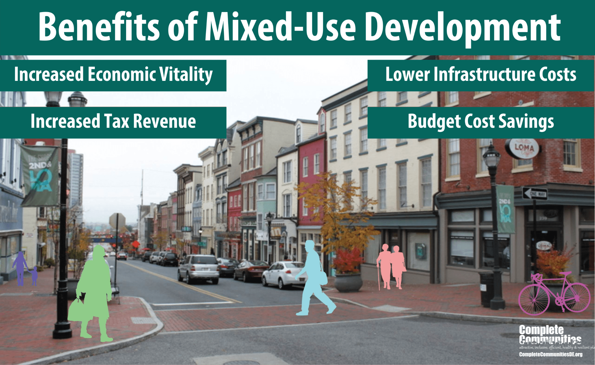
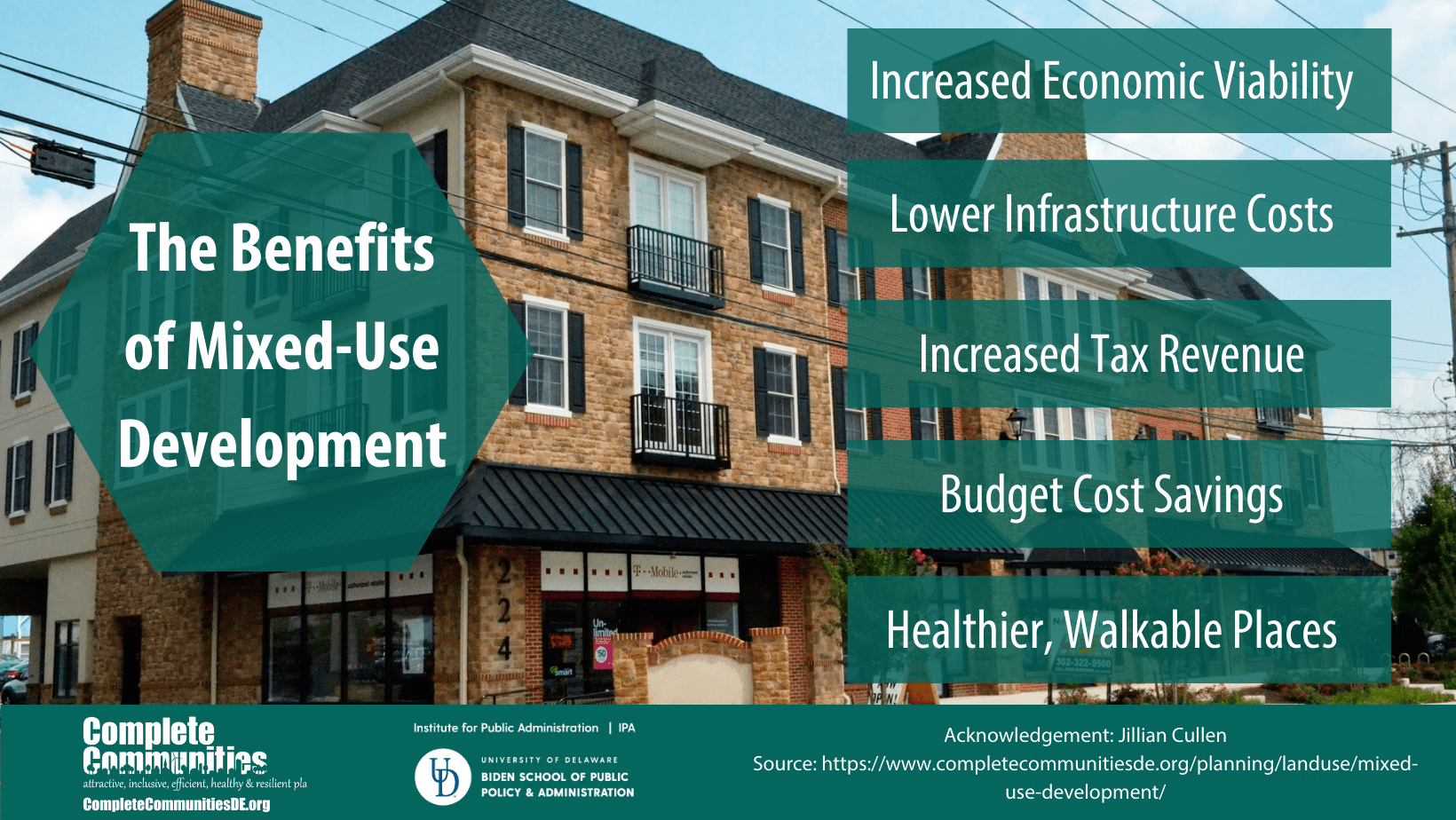
This section discusses the concept and benefits of mixed-use development, which can be defined as integrated development that incorporates two or more types of land uses (e.g., housing, offices, retail, entertainment, institutions, services, restaurants). Mixed-use development can help local governments better respond to a growing market demand for walkable, vibrant communities with convenient transit linkages, proximity to jobs, and access to nearby public services and spaces and activity-oriented destinations.
Topics in this section
- What Is Mixed-Use Development?
- How Can Delaware Communities Implement Mixed-Use Development?
- Ways Local Governments Can Foster Implementation of Mixed-Use Development
- Examples of Successful Mixed-Use in Delaware
What Is Mixed-Use Development?
As defined by the MRSC of Washington, mixed-use development is characterized as pedestrian-friendly development that blends two or more residential, commercial, cultural, institutional, and/or industrial uses. Mixed use is one of the ten principles of Smart Growth, a planning strategy that seeks to foster community design and development that serves the economy, community, public health, and the environment.

While mixed use has become a popular buzz word, the term can be confusing. It is not just limited to a multi-story development that incorporates commercial use on the first floor with residential uses on upper floors. The Urban Land Institute’s Mixed-Use Development Handbook characterizes mixed-use development as one that 1) provides three or more significant revenue-producing uses (such as retail/entertainment, office, residential, hotel, and/or civic/cultural/recreation), 2) fosters integration, density, and compatibility of land uses, and 3) creates a walkable community with uninterrupted pedestrian connections.
A blog, don’t get mixed up on mixed use, by the folks at PlaceMakers clarifies that mixed use is: … three-dimensional, pedestrian-oriented places that layer compatible land uses, public amenities, and utilities together at various scales and intensities. This variety of uses allows for people to live, work, play and shop in one place, which then becomes a destination for people from other neighborhoods. As defined by The Lexicon of the New Urbanism, mixed-use is multiple functions within the same building or the same general area through superimposition or within the same area through adjacency… from which many of the benefits are … pedestrian activity and traffic capture.
Mixed-use zoning allows for the horizontal and vertical combination of land uses in a given area. Commercial, residential, and even in some instances, light industrial are fit together to help create built environments where residents can live, work, and play. The Placemakers’ blog, and a brief prepared by the Village of Caledonia, WI, further explains that while there are many forms of mixed-use development, it can be categorized three ways:
Vertical Mixed-Use Development
- Combines different uses within the same building
- Provides for more public uses on the lower floor such as retail shops, restaurants, of commercial businesses
- Provides for more private uses on the upper floors such as residential units, hotel rooms, or office space.
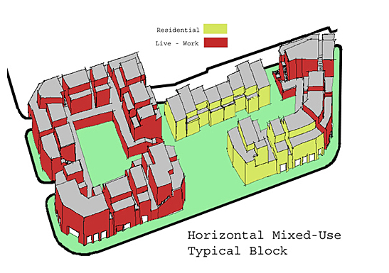
Horizontal Mixed-Use Development
- Consists of single-use buildings within a mixed-use zoning district parcel, which allows for a range of land uses in a single development project
- Provides for a variety of complementary and integrated uses that are walkable and within a given neighborhood, tract or land, or development project
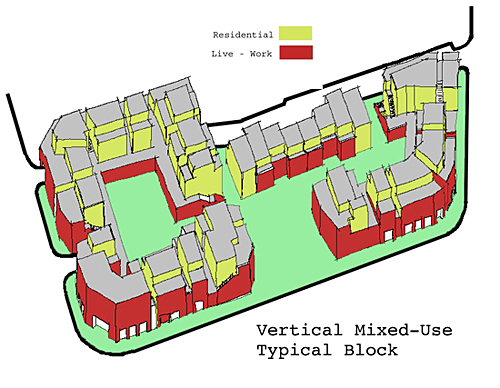
Source: Placemakers.com
Source: Placemakers.com
How Can Delaware Communities Implement Mixed-Use Development?
Comprehensive Plan/Community Vision
A comprehensive plan is a legal document used by a local government to guide future land use, and serves as the basis for zoning, subdivision, and land use codes. Vision-based and community-driven plan, a comprehensive plan can provide a foundation for establishing what a community wants to preserve, develop, and change. It guides public investment and private development decisions—including the intensity, location, and types of development that may occur.
Many Delaware local governments have established a vision for mixed-use development within their Comprehensive Plans or updates to plans. The City of Newark, Delaware’s 2014 comprehensive plan update utilizes visioning to provide a clearer picture of the objectives the City wishes to achieve. The vision process utilized a structured planning approach to evaluate the Strengths, Weaknesses, Opportunities, and Threats (SWOT) in the community. Newark’s vision reflects three principle values that mirror Complete Community elements: 1) a healthy and active community, 2) a sustainable community, and 3) an inclusive community. Mixed-use development supports all each of these values. Support for this vision is further detailed in the plans’ economic development and land development chapters.
The 2010 Comprehensive Plan update for Town of Elsmere, Delaware recommends zoning code amendments to “encourage redevelopment activities, including the conversion of the Kirkwood Highway into a Main Street by allowing for mixed land uses.”
The Town of Middletown, Delaware’s 2012 comprehensive plan update recommends a change to the 2005 plan, which designated a number of parcels as commercial. The plan recommends mixed use to “provide flexibility so that the market can dictate the best combination of uses for these parcels. This designation is also applied to parcels that have been approved for, or are developing as, mixed-use communities.” The comprehensive plan also states that the all residential districts and the C-2 and C-3 Zones would be consistent with the “Mixed Use” designation. The C-2 and C-3 zones provide flexibility for mixing residential and commercial land uses and applying contemporary planning principles to new development plans. Examples of areas where this approach was applied include undeveloped areas in Westown master planned area and the downtown commercial area.
Planners with the University of Delaware’s Institute for Public Administration assisted the Town of Middletown, Del. in incorporating mixed-use land use designations into their recently updated Comprehensive Plan. The orange areas on the map indicate mixed-use classifications.
Community visioning exercises can also build community consensus for future land use and development. Through a charrette process, the City of Dover and Dover Downtown Partnership created a Dover Transit Center Neighborhood Plan that discussed the desire for mixed-use development in downtown Dover.
Zoning
Zoning the chief means of implementing a comprehensive plan, consisting of a written document and a map. It is a legal device that establishes zoning laws, establishes districts, and regulates:
- The types of land uses permitted
- The intensity or density of development
- Height, bulk, and placement of buildings or structures
- Other conditions deemed necessary to direct development
Once a jurisdiction updates or amends its comprehensive plan to provide a vision for mixed-use development, the zoning code and official map should be amended within 18 months, as per state law. Mixed-use zoning can be accomplished in two ways: 1) modifying existing zoning district designations to loosen allowable development under each or 2) creating new districts specifically designated to be for mixed-use development.
Many Delaware local governments have adopted or amended zoning code provisions to allow for mixed use development. For example, the City of Newark’s zoning code provides a mix of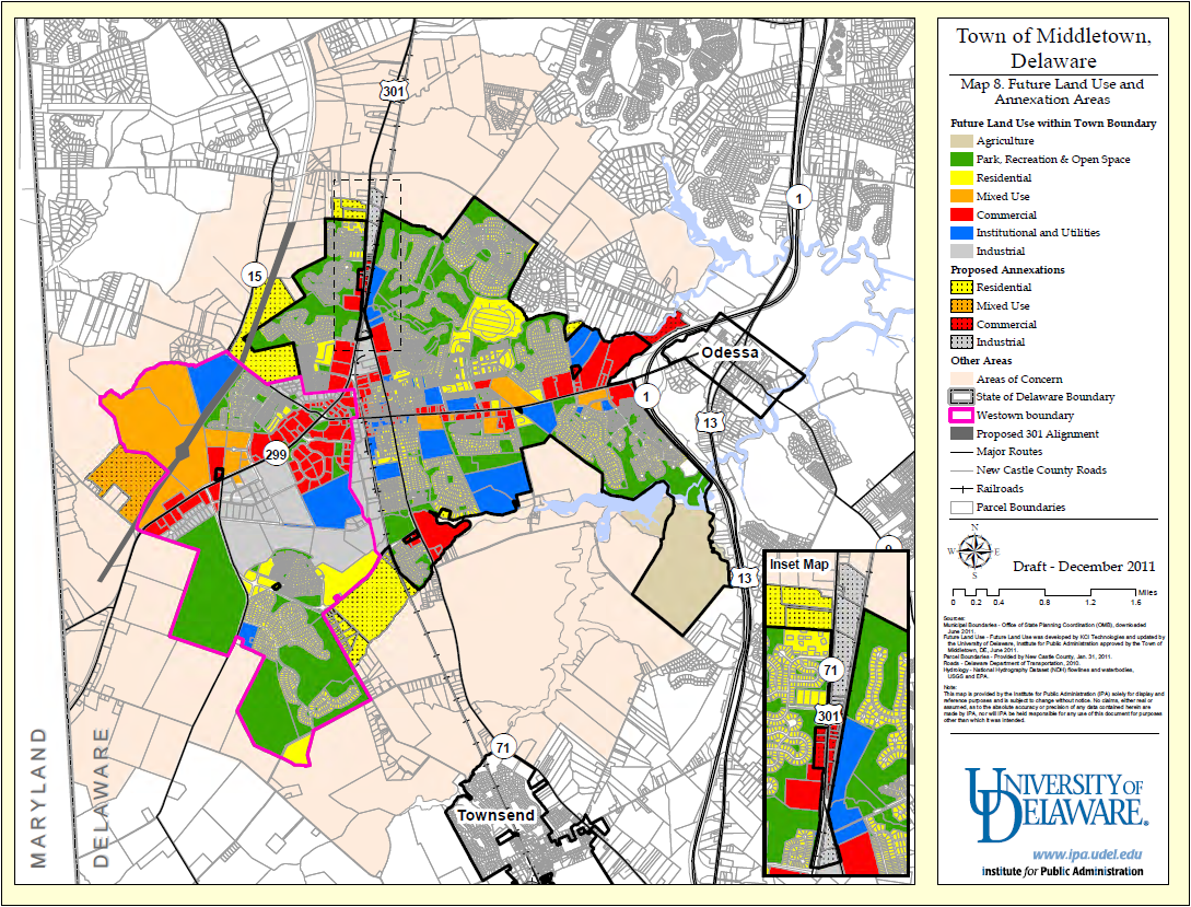 commercial, residential, and institutional uses within several zoning districts. The City of Lewes’ zoning code permits a mix of uses in its Town Center, Town (Historic) Center, and Marine Commercial Zones. The provisions justify the need for mixed use to “strengthen connections between the town center and the City’s residential districts, create a pedestrian corridor…, provide for establishments…that are vital to a year-round working community, encourage a mix [of uses] to promote the economic stability of the area, and provide for apartment dwellings…but only on the stories above street level.”
The Town of Middletown has incorporated a number of the “Better Models” principles into its zoning code. One example is in the downtown area where the C-2 (Downtown Commercial) Zone encourages:
…a traditional downtown that reinforces the historic character and scale of Middletown and encourages a mixed use pedestrian environment. Development in this zone should be pedestrian-friendly. This character can be achieved through the use of sidewalks, street trees, public spaces, building massing, articulation and orientation, signage, land uses, traffic calming and scale and location of parking. Land uses should be both residential and nonresidential. Business should be neighborhood, community and tourist-serving including specialty retail, personal and professional services.
Another example in the zoning ordinance is the R-2 Zone, which allows traditional neighborhood design (TND) subdivisions to the list of permitted uses. To encourage compact design, the zone provides for reduced minimum lot sizes, lot widths, and building widths. Section 2 (68) defines a traditional neighborhood design as one that:
…incorporates various combinations of planting techniques providing for an integrated mix of housing types and sizes with a pedestrian-friendly layout, street trees, reduced setbacks, alleyways serving some of the lots, and other features consistent with such a community.
In addition to these examples, APA prepared a Model Mixed-Use Zoning District Ordinance.
The model zoning district ordinance achieves two key Smart Growth principles—a mix of land uses and compact building design. The provisions provide for a commercial zoning classification that allow for, rather than require, a vertical mix of commercial and residential uses within the same building. The intended physical pattern of development is reminiscent of the design of classic main streets within central business districts of older cities.
Community Design
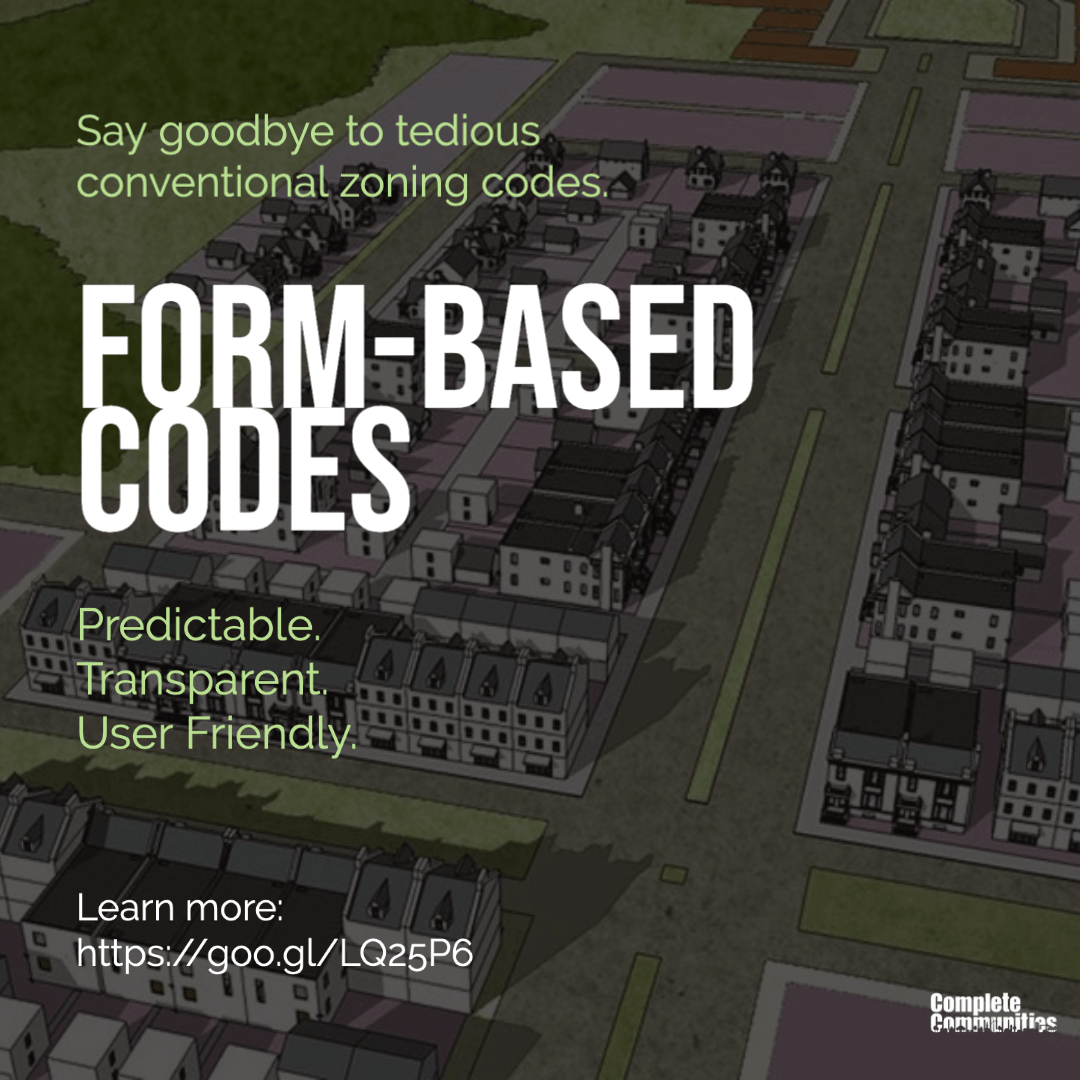
Form-based codes (FBCs) are a relatively new, innovative way of addressing community design. FBCs are geared toward achieving connected, vibrant, and walkable places that allow for a mix of uses. In 2009, New Castle County implemented a form-based code as a new Hamlets & Villages chapter within its existing Unified Development Code, to empower the development of denser new towns. New Castle County’s “Smart Code legislation” is designed 1) preserve open space and farmland, 2) provide of a variety of transportation choices, 3) allow for mixed uses, 4) support a range of housing opportunities and choices, 5) create walkable neighborhoods, 6) foster distinctive and attractive communities for a strong sense of place, 7) promote predictable, fair, and cost-effective development decisions, 8) direct development toward existing communities, and 9) provide compact building and efficient infrastructure design.
The newly planned community, the Town of Whitehall, is designed to meet aspects of New Castle County’s Smart Code. The Town of Whitehall’s master plan and its Architectural Pattern Book employs classic Traditional Neighborhood Development (TND) principles, use of form-based codes, and incorporates a mix of uses within eight hamlets and villages.
The Town of Whitehall is planned to be developed on 1,555 acres of wetlands. Placemakers developed the plan for Whitehall and an aggressive outreach plan to increase interest in the development. The development of a town brand and subsequent social media strategy will lead to a targeted audience that will make up the town’s identity. By pairing a newly-founded identity with deliberate planning such as, walking trails, wetland and canal vistas, and walkable streets, the Town of Whitehall is well-positioned to become a livable and vibrant community.
Ways Local Governments Can Foster Implementation of Mixed-Use Development
Mixed-use development is a useful tool for encouraging compact development in designated growth areas, innovative land use management, efficient multimodal transportation systems. Several strategies should be considered to effectively implement mixed-use development.
Strategies to Consider
- Identify opportunities for infill and redevelopment to take advantage of existing infrastructure and minimize the need for new facilities.
- Identify provisions within zoning, subdivision, development, and other regulatory codes that prohibit mixed-use development.
- Target development opportunities to nearby, compatible land uses to shorten trips and facilitate alternative modes of transportation, such as walking, bicycling and public transit.
- Adopt form-based codes that provide a set of design regulations that give form to features of the built environment and foster pedestrian access, safety, and comfort.
- Assess the real estate market and consider the viability of mixed-use development in a specific region, community, or district.
- Prepare a market analysis to estimate market demand and supply for new or expanded residential, commercial (e.g., retail and service business categories), and industrial business opportunities
- Provide a combination of financial and regulatory incentives to mixed-use developers, such as permit fee reductions, tax abatements, expedited development approval processes, and providing density and building height or floor area bonuses.
- Consider incentives for mixed-use development projects that are located near transit stations or hubs, areas that are targeted for market-ready (re)development, and/or are located within Downtown Development Districts.
- Provide regulatory flexibility with regard to building height, housing density, floor area, lot coverage, yard setback, landscaping, and other zoning provisions for mixed-use developments in key areas targeted for growth (e.g. downtowns, main streets, town centers, and other core areas).
- Consider modern approaches to parking management as outlined by an APA Parking Solutions brief. These approaches include reducing parking requirements through strategies such as shared parking, maximum parking standards, fee-in-lieu programs for downtown districts, shared vehicles, proximity to transit, valet parking, and bicycle parking.
Addressing Regulatory Barriers to Mixed-Use Development
Local governments can foster mixed-use development by preparing for market-ready (re)development opportunities. A report by IPA suggests that local governments review zoning codes, subdivision regulations, land development regulations, and fire and building codes to address regulatory barriers. In addition, the efficiency of local permitting processes should be reviewed and streamlined. Zoning, permitting, financing, environmental, and political barriers to mixed-use development should be evaluated and addressed.
Examples of Successful Mixed Use in Delaware
Paynter’s Mill

Paynter’s Mill, Lewes, Delaware
Paynter’s Mill in Milton, Delaware, is regarded as one of the state’s best examples of a successful mixed-use developments. The community was voted the 2007 community of the year and has continued to grow. Paynter’s Mill consists primarily of three distinct residential communities with a large offering of amenities that include a clubhouse, meeting spaces, fitness facilities, and a pool. In addition to the residential offerings, Paynter’s Mill shops are nearby and growing. Good design features include: back alleys, minimum setbacks, narrow streets, small street lights, wider sidewalks, and shared open space.
Auburn Valley Master Plan
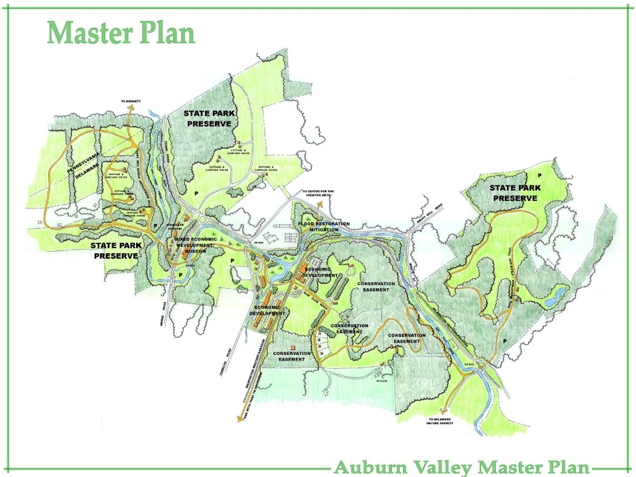
Concept map of Yorklyn Village, which is part of the Auburn Valley Master Plan, Yorklyn, Delaware
The Auburn Valley Master Plan, prepared in 2011 for Delaware’s Department of Natural Resources and Environmental Control’s (DNREC) Division of Parks and Recreation, serves as the basis for the design and redevelopment of a former industrial site in Yorklyn, Del. The site went through several transitions as an active gristmill, sawmill, and papermill. When the National Vulcanized Fibre (NVF) Company mill closed in 2009, DNREC pursued discussions with developers and investors. A working group was formed to secure and gather information about the site. The master plan sets forth a vision to allow for mixed-use redevelopment of the property while preserving the scenic viewshed of the historic Auburn Heights mansion, addressing site contamination and flooding issues, providing quality recreation opportunities, and improving transportation in the area. The plan presents several options to renovate some of the historic buildings to accommodate commercial/retail businesses, provide new opportunities for the area to be revitalized into a vibrant community with an abundance of green space and respect for the surrounding area.
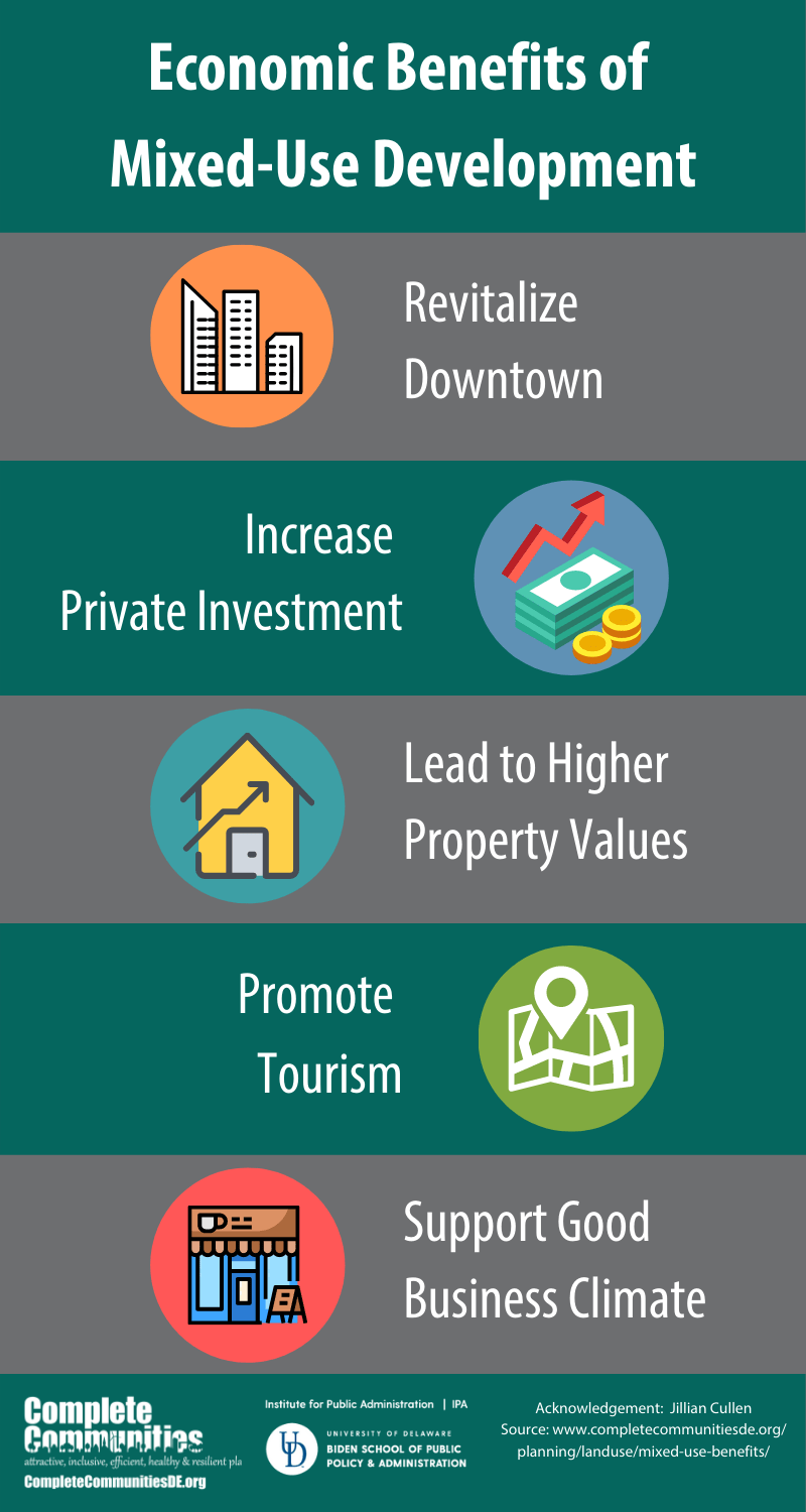
Helpful Infographics