Introduction
The 2015 Strategies for State Policies and Spending provides a policy framework for planning in Delaware and is organized around the following principals:
- Develop a More Efficient and Effective Government by coordinating local land use actions with State infrastructure and service delivery, largely through implementing the Strategies for State Policies and Spending.
- Foster Economic Growth by enabling a predictable and transparent land use review and permitting process and leveraging state and local investments in infrastructure.
- Improve Educational Opportunities for Delaware’s children by working with school districts and local governments to locate new schools in cost-effective neighborhood settings in accordance with the Strategies for State Policies and Spending and local government comprehensive plans.
- Enhance the Quality of Life for All Delawareans by creating “Complete Communities” rich in amenities and services, encouraging a range of choices for residence and businesses, and protecting natural resources and our agricultural economy.
The Delaware Office of State Planning Coordination (OSPC) works to improve the coordination and effectiveness of land use decisions made by state, county, and municipal governments while building and maintaining a high quality of life in the State of Delaware. OPSC circuit-rider planners, the Planning Services Group of the Institute for Public Administration (IPA) at the University of Delaware, and private-sector planning and consulting firms can provide technical assistance with preparation of local government comprehensive plans.
Topics discussed in the following section:
- What Is a Comprehensive Plan?
- Comprehensive Plans and Community Engagement
- Roles in the Comprehensive Planning Process
- Comprehensive Plan Adoption Process
- Zoning, Subdivision, and Land Use Codes
- State PLUS Process
- Comprehensive Planning Best Practices
What Is a Comprehensive Plan?
Planning Framework in Delaware
The comprehensive plan is the foundation for planning in Delaware. Zoning, subdivision, and other regulatory tools are the principal means for implementing the plan. The comprehensive plan and land use codes (zoning and subdivision) are important because they will continue to be the principle mechanisms through which many of the elements that make up a complete community are legislated, permitted, encouraged, and managed.
The comprehensive plan communicates a community’s goals and objectives, provides a blueprint for future land use, and serves as the basis for zoning, subdivision, and land use codes. A comprehensive plan is a document consisting of text and a series of maps that:
- Identifies a community’s goals and sets forth its vision for the future;
- As part of its formulation, reaches out to a diverse group of stakeholders for their help, ideas, and expertise in the developing those goals and identifying the actions needed to achieve them; and
- Provides guidance for establishing the laws, policies, and programs to achieve implementation, including sometimes a master plan.
Delaware Code Requirements
More than just a helpful guide, the comprehensive plan is a requirement for all local governments in Delaware, and it is treated as law. Title 22, Chapter 7, Section 702 of the Delaware Code requires Delaware municipalities to prepare comprehensive plans that “[encourage] the most appropriate uses of physical and fiscal resources of the municipality and the coordination of municipal growth, development, and infrastructure investment actions with those of other municipalities, counties and the State.” Delaware counties are also required to prepare and adopt comprehensive plans. The standards for county comprehensive plans are found in Title 9 of the Delaware Code.
Comprehensive plans for cities and towns having populations under 2,000 persons, must adopt a municipal development strategy. Larger cities and towns must develop more detailed comprehensive land use plans. Each Delaware municipality must review its adopted comprehensive plan at least every five years to determine if its provisions are still relevant. In addition, an adopted comprehensive plan must be revised, updated and amended as necessary, and readopted at least every 10 years.
Comprehensive Plans and Community Engagement
A comprehensive plan expresses a community’s values and preferences. It is the foundation for development decisions, laws, regulations, and policies. It reflects a community’s desired future.
To ensure that a comprehensive plan articulates these values, is it essential to engage the community. The question is how to secure its participation. One way is to rely on the governing body, whom voters elected to represent them, staff, or appointed committees and commissions. In addition, direct input is needed from the community through public workshops, forums, and hearings. Many communities are supplementing the traditional high-touch approaches with high-tech formats that opportunities for public engagement via the internet and social media. Combining high-touch and high-tech public engagement methods gives a plan legitimacy and ensures that it reflects the values of the community.
Each jurisdiction must engage the public according to its resources, size, and issues. However accomplished, it is essential to build a collaborative environment that actively involves the community in all aspects of the decision-making process, including the development, update, and/or revision of a comprehensive plan. A sustainable, comprehensive plan is community driven and focused. Stakeholders representing diverse community interests must be involved from the onset in a comprehensive planning process. Their input is vital to the development a community vision, the establishment of goals and objectives, and the review a draft plan prior to adoption by the local governing body.
While the various strategies for community engagement are important, it is essential that adequate notice of every meeting, workshop, forum, hearing, etc. is provided, that everyone who wishes to comment or participate is given that opportunity, and that decisions are transparent.
Roles in the Comprehensive Planning Process
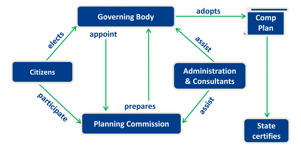
“It takes a village” is perhaps an appropriate way to describe how a community’s comprehensive plan should be developed. Planning partners such as a local government’s governing body, administration (and consultants), planning commission, and citizens have a role in developing a vision, building consensus, obtaining citizen input, refining and adopting a comprehensive plan that is consistent with the 2010 Strategies for State Policies and Spending.
Governing Body
The governing body is the elected officials of a local government that are elected by qualified voters of the jurisdiction. Depending on the jurisdiction in Delaware, the governing body may be called a city or town council, town commissioners, county commissioners, or levy court. The governing body’s role in comprehensive planning includes:
- Appointing planning commissioners,
- Adopting or updating the comprehensive plan,
- Adopting comprehensive rezoning regulations that are consistent with plan’s land use designations, and
- Submitting an annual report on plan implementation to Office of State Planning Coordination.
Planning Commission
The responsibility of a local government’s planning is to prepare a comprehensive plan for adoption by the governing body. All plans should have some provision for community engagement. Public input is most useful early in the planning process, and should help form the plan’s goals and recommendations. A planning commission, working with the local government’s administrators and consultants, may schedule workshops to gain public insight and draft a document for recommendation to the governing body.
In addition to plan preparation, many governing bodies rely on their planning commissions for advice on development-related issues. Planning commissions often make recommendations to the governing body on rezonings, changes to zoning or subdivision ordinances, and to the board of adjustment on requests for variances and/or special exceptions. Many review, and some approve, development (subdivision and site) plans.
Administrative Staff and Consultants
A local government’s administrative staff may seek assistance from OSPC, IPA, or other consultants to help with any or all aspects of comprehensive plan preparation and public participation process. Typical consultant roles might include:
- Assisting local officials to develop plan,
- Providing research on issues as needed,
- Organizing plan into document,
- Assisting with meeting state requirements, and
- Assisting with community outreach.
Citizens and Other Stakeholders
Citizens include voters (may include non-resident property owners in some jurisdictions), who elect members of the governing body. Other stakeholders who are members of the local community and may be impacted by land use plans should also be included in the public participation process. Examples of the types of contributions from members of the local community may include:
- Participating in public hearings and meetings,
- Lending professional expertise,
- Helping gather information for plan, such as, land use surveys,
- Acting as advocates for plan, especially after adoption, and
- Serving on ad hoc committees to advise planning commission or study issues in depth.
State Role—Plan Certification
Title 29, Section 9103 of the Delaware Code requires that the governor (or the State Planning Coordinator, if the governor so designates) certify county and municipal comprehensive plans. The certification process involves review and comment from state departments and agencies. OSPC organizes the comment process and works with each jurisdiction on items required for plan certification.
The state review is based on statewide land development goals, policies and criteria established by the Governor, the Cabinet Committee on State Planning Issues, state laws or regulations, or the State’s most recent capital budget. It is not intended to preempt, replace, or override local planning efforts. Its primary focus is the “…potential fiscal impacts of the proposed county or municipal comprehensive plan as they relate to State-funded infrastructure and services, including but not limited to transportation, water and sewer systems, public schools, affordable housing, and public safety.”
Comprehensive Plan Adoption Process
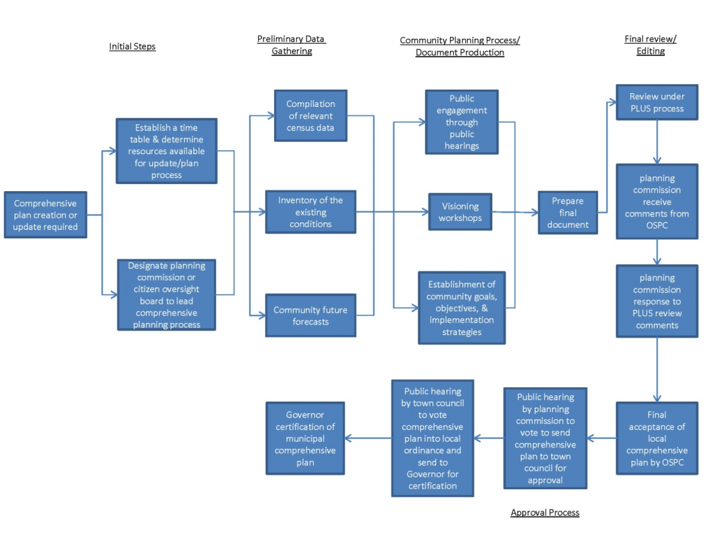
The comprehensive plan adoption process must be tailored to the needs of each local jurisdiction. The graphic illustrates a typical flow of work.
Typical Comprehensive Plan Elements
Although each jurisdiction must organize its comprehensive plan according to its needs and the state requirements, a typical plan might contain some or all of the following elements.
- History of the jurisdiction
- Description of process leading to plan adoption especially public participation
- Community profile
- Environmental resources
- Historic resources
- Housing
- Community facilities and services
- Transportation
- Land use—existing and future
- Growth and annexation
- Implementation strategies
How to get it done—zoning, annexation, capital improvements programming, grant applications, Main Street Program, Master Planning
Land Use Element
The land use element of a comprehensive plan consists of text and maps regarding land use. Land use is a general description of how land is, or is designated to be, occupied (or used). It is portrayed on maps that show current (existing) and desired (future) locations of the various types of land uses. Basic land uses are residential, commercial, industrial, and vacant. Many land use maps also identify land used for agriculture, open space, institutional or community facilities (schools, hospitals, public safety facilities), and utilities (water storage towers, sewage treatment plants, electric substations). The number of land use designations depends on a jurisdiction’s size and its development pattern.
Future land use describes and portrays a jurisdiction’s desired (future) development pattern. It includes text that describes future land uses within the jurisdiction in general terms and a map showing their locations. It is important because it forms the basis for the state-mandated comprehensive rezoning that must be accomplished within 18 months of plan adoption.
Zoning, Subdivision, and Land Use Codes
Zoning, subdivision, and land use codes are the principle ways to implement (carryout) comprehensive plans. Regardless of whether they are called ordinances, codes, standards, or regulations, they are laws with penalties for violation.
Zoning
What is Zoning?
The purpose of zoning is to protect health safety, and general welfare. It accomplishes this by regulating how land is used and setting standards for building types, sizes, and heights. Early zoning regulations were characterized by rigid separation of land uses and inflexible bulk standards (lots sizes, setbacks from property lines, parking standards, etc.). Contemporary zoning codes frequently include standards that encourage (and, in some cases, mandate) transit-oriented development (TOD), historic preservation, integration of pedestrian paths and bikeways in subdivisions, and protection of environmental resources (floodplains, aquifers, and wetlands). They also permit developments that integrate detached homes, duplexes, townhomes, and apartments, and entire communities comprised of residential, commercial, employment, and recreational opportunities. More recently, form-based codes are concentrating more on the urban form (streetscapes and building design) rather than focusing on the separation of uses.
Zoning divides a municipality into districts (zones or zoning districts) and establishes regulations for each district. A zoning ordinance consists of a written document and a map. The ordinance specifies the types of activities (uses) that can occur in each district either as a matter of right (in all circumstances) or under certain conditions (conditional uses and/or special exceptions). It also regulates building height, lot sizes, setbacks from streets and adjacent lots, yards and green space, number and sizes of signs, space for off-street parking. Many modern ordinances include regulations governing development in the vicinity of floodplains, wetlands, wellheads, and aquifers.
The zoning map depicts the boundaries of each zoning district within the jurisdiction. As state law mandates, zoning districts must be consistent with land use designations. The graphic below illustrates the link between the land use designations in a comprehensive plan and the zoning districts enacted following plan adoption. It would be inconsistent to place a property, whose land use is designated residential, in either a commercial or an industrial zoning district. It would be consistent to place a residentially designated property in any of the four residential zoning districts.
Legal Basis for Zoning in Delaware
Title 22, Chapter 3 of the Delaware Code authorizes municipalities to adopt zoning regulations. Section 301 states that:
…the legislative body of cities and incorporated towns may regulate and restrict the height, number of stories and size of buildings and other structures, percentage of lot that may be occupied, the size of yards, courts and other open spaces, the density of population, and the location and use of buildings, structures and land for trade, industry, residence or other purposes.
Section 303 of Title 22 requires that zoning regulations be made in accordance with municipal comprehensive plans. There is no provision for the adoption of municipal subdivision regulations in the Delaware Code. County zoning and subdivision provisions are found throughout Title 9 and sometimes vary from county to county.
Land Use and Zoning Link—Clayton, Delaware
Subdivision
Subdivision refers to the process of splitting up or assembling land for development. The regulations governing this process designate utility locations, street rights-of-way, open space, and common areas. They also outline the services, such as water, sewer, gas, and electricity, and amenities that a developer must install prior to sale of subdivided (or assembled) land.
Land Use Codes
A land use code is an ordinance that combines the zoning and subdivision regulations into a single document. The American Planning Association (APA) describes a Unified Development Ordinance (UDO) as a local policy instrument that combines traditional zoning and subdivision regulations, along with other desired city regulations, such as design guidelines, sign regulations, and floodplain and stormwater management, into one document. UDOs can:
- Better respond to the way development occurs. Over the years, the line between zoning and subdivision have become blurred as development-review processes have become more sophisticated often involving subdivided and unsubdivided land, mixed-use communities, phased construction, and environmental management.
- Enhance efficiency of land use regulations. Planning commissioners, staff, elected officials, applicants, and the general public have only one set of standards and regulations with which they need to become familiar and the approval processes for every development-related application (ranging from a fence permit to a new town planned development) is included.
- Avoid the overlapping regulations, conflicting standards, and often inconsistencies often found in separate zoning and subdivision documents.
Several Delaware local governments (Bellefonte, Blades, Bridgeville, New Castle County, Ocean View, Townsend, and Wyoming) have merged zoning and subdivision into a single ordinance typically called a unified development ordinance, a land use code, or a land use and development code. A jurisdiction should not create a land use code simply by copying its subdivision regulations into the zoning ordinance or vice versa. However, a jurisdiction that decides to do this creates an opportunity for modernizing the way regulations are organized and administered.
State PLUS Process
In addition to comprehensive plan certification, the state reviews a number of other local land use actions. This procedure is frequently referred to as the Preliminary Land Use Service (PLUS) process. Although the steps leading to review are the same for every project, follow-up actions differ somewhat for each type of project. Coordinated by OSPC, these reviews bring together state agency planners to comment on local land use actions prior to adoption or approval by counties and municipalities.
Because the provision of many infrastructure facilities and services is a shared responsibility in Delaware, an important feature of these reviews is that they bring state agency representatives, local governments, and applicants together at a single meeting. Another significant aspect is that they take place at the start of local development-approval processes before either state agencies or developers are locked into funding commitments.
State Agency Participants
Although the Delaware Code stipulates that any state agency must participate in the review process upon request from OSPC, the following agencies are typical contributors:
- Department of Transportation
- Department of Natural Resources and Environmental Control
- State Housing Authority
- State Fire Marshal
- Department of Agriculture
- Public Service Commission
- Department of Health and Social Services, Division of Public Health
- Economic Development Office
- Department of Education
Purpose
- To ensure that local land use decisions are compatible and consistent with the plans and policies of all levels of government.
- To channel the state’s finite resources in an efficient, effective, and timely manner.
- To simplify and coordinate state regulatory and review process.
Projects Subject to State Review
Section 9203 of the Delaware Code mandates that any of the following projects undergo state review.
- Residential subdivisions that include internal road networks and more than 50 units.
- Non-residential subdivision proposals with total floor space exceeding 50,000 square feet.
- Applications for rezoning, conditional use, site plan review and/or subdivision within an environmentally sensitive area as determined by a local jurisdiction’s comprehensive plan.
- Applications for annexation that are inconsistent with a local jurisdiction’s comprehensive plan.
- Rezoning applications that are inconsistent with the local jurisdiction’s comprehensive plan.
- Any local land use regulation, ordinance or requirement sent to the OSPC by a local jurisdiction for advisory comment.
- County and municipal comprehensive plans.
- Any additional projects required to be referred to the pre-application review process as established by a local jurisdiction.
Comprehensive Planning Best Practices
This section provides several best practices in Delaware for public engagement activities and land use code elements.
Community Engagement
The state acknowledges that citizen participation is essential to the process by which administrative regulations are adopted, amended, or repealed, and may initiate the process by which the validity and applicability of regulations is determined. In addition, local governments are encouraged to develop community engagement strategies to ensure that decisions reflect public needs and interests, consider diverse viewpoints and values, and are made in collaboration and with consensus of all stakeholders.
Newark Neighborhood Meetings: Comprehensive Development Plan V
The graphic below shows one aspect of the City of Newark’s public engagement program. In addition to a number of “topic meetings,” the program included three neighborhood workshops. Each workshop was held at a location in each of the three neighborhood groups shown below.

Source: Comprehensive Development Plan: Progress Report, Newark, Delaware
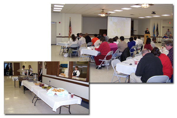
Clayton Community Dinner: 2008 Comprehensive Plan Update
Disappointed with the turnout for its first community workshop leading up to adoption of the 2008 plan, the Clayton town council and planning commission sponsored a community dinner at the fire department’s meeting and banquet facility. Invitations to the dinner were placed in town utility bills, and the Clayton SunTimes posted an article in its web edition that ran two weeks prior to the event. Approximately 100 people attended the dinner.
Land Use Codes
This section looks at best practices in three recently-revamped land use codes. The first is a tenant of the Complete Communities way of thinking—mixed use. In 2010, the Town of Ocean View restructured its regulations for mixed-use residential development and crafted new mixed-use standards to permit development with both residential and commercial development.
The next two best practices focus on organizing. Regardless of whether a jurisdiction’s land use standards are in zoning and subdivision ordinances or an all-in-one land use code, it is important to present the regulations clearly. The first comes from the Town of Bellefonte where the list of uses allowed in each zoning district is in a table. The next organizational tool is a graphical outline of the development-approval process in the Town of Blades.
Mixed-Use Development in Ocean View Land Use and Development Code
Ocean View’s Land Use and Development Code provides for two types of mixed-use developments. The PRC District provides for a mix of residential dwellings, although a limited square footage of commercial development is allowed. The MXPC Zone permits a greater mix of residential and commercial. As the articulated in the purpose and intent statement, a concept plan is required at the time of rezoning.
| Article IV. Planned Community Zoning Districts § 999-46. Established and PurposeA. Established—See also § 999-22. (1) Residential Planned Community (RPC) Zoning District. (2) Mixed-Use Planned Community (MXPC) Zoning District. B. Purposes and Intents. (1) The planned communities envisioned in these Districts are intended to have appropriate mixes of residential and commercial uses. Accordingly some planned communities might have only residential uses, others might contain mostly residential use with a small portion of commercial activities, while others might appropriately include up to 50% commercial within a single planned community. (2) To create a superior living environment through unified development, a concept plan must be approved in order for the petition for reclassification to be granted. (3) By permitting mixes of residential dwelling units and compatible commercial uses, innovative design is encouraged. (4) Flexible dimensional standards are allowed in order to minimize infrastructure costs. (5) Environmental resources are conserved through requirements for common open space. |
Uses Organized Into a Table by Zoning District in Bellefonte Land Use Code
Adopted in 2010, Bellefonte’s Land Use Code reformatted the way permitted uses are presented from a dialogue organized by zoning district to the table shown below.
Development Review Process
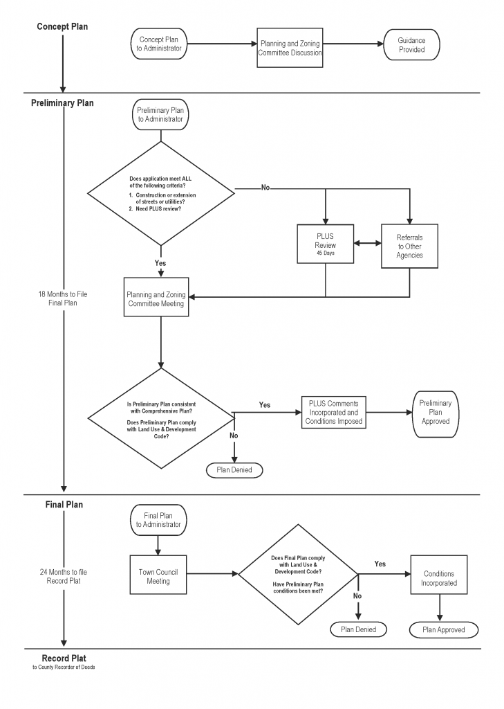
Graphic Outlining Development Review in Wyoming’s Land Use and Development Code
This is an example of how the development-review process in Wyoming is kept simplified, regardless as to whether the review is to approve a subdivision plat or a site plan.
Use of Graphics to Illustrate Planning Concepts
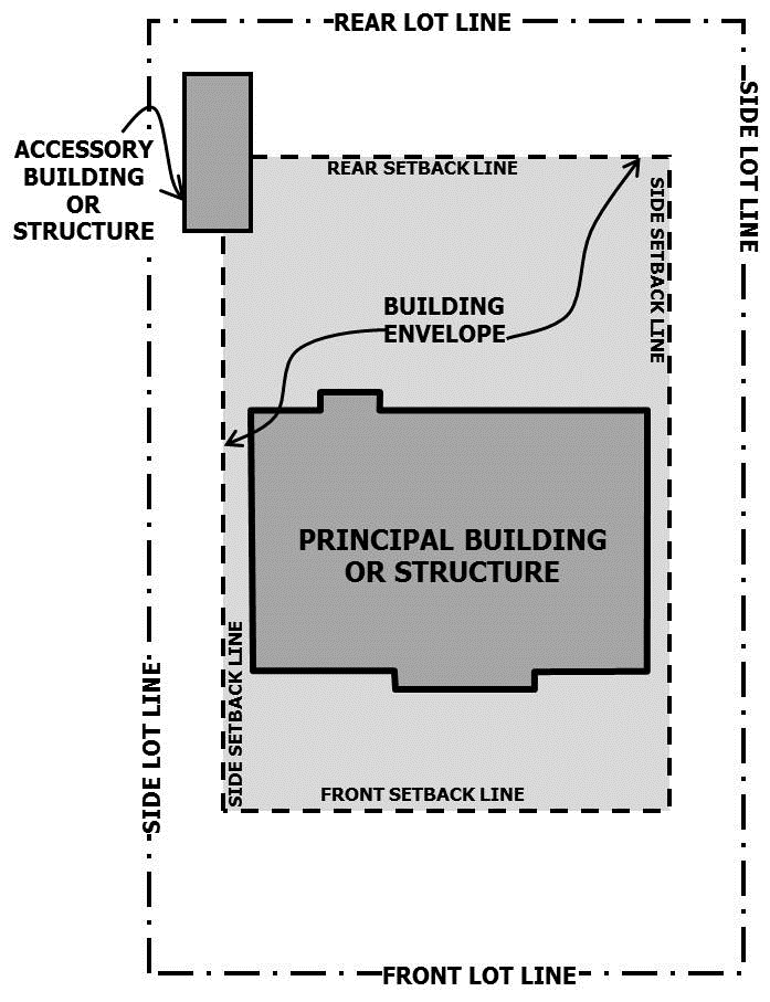
Graphics can be incorporated into a zoning, subdivision, or land use code. In this example, developed for the Delaware Planning Education Program, the graphic helps to illustrate and promote understanding of the planning terms that are used in local government regulations.
Building—Any structure having a roof supported by columns or walls intended for shelter, housing, or enclosure of any individual, animal, process equipment, goods, or materials of any kind.
Building, Accessory—A subordinate structure on the same lot as a principal building in which is conducted a use that is clearly incidental and subordinate to the lot’s principal use.
Building, Principal—A building on which is located the principal use of the lot on which it is located.
Setback Line—The line that is the required minimum distance from any lot line and that establishes the area within which the principal structure must be placed. See also Yard.
Structure—A combination of materials to form a construction for use, occupancy, or ornamentation whether installed on, above, or below the surface of land or water.

